IMAGES TAKEN NEAR TO
Moor Lane, BIRMINGHAM, B6 7HH
Introduction
This page details the photographs taken nearby to Moor Lane, B6 7HH by members of the Geograph project.
The Geograph project started in 2005 with the aim of publishing, organising and preserving representative images for every square kilometre of Great Britain, Ireland and the Isle of Man.

There are currently over 7.5m images from over14,400 individuals and you can help contribute to the project by visiting https://www.geograph.org.uk
Image Map
Images are licensed for reuse under creativecommons.org/licenses/by-sa/2.0
Notes
- Clicking on the map will re-center to the selected point.
- The higher the marker number, the further away the image location is from the centre of the postcode.
Image Listing (69 Images Found)
Images are licensed for reuse under creativecommons.org/licenses/by-sa/2.0
Image
Details
Distance
1
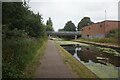
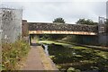
Tame Valley Canal towards Perrywell Road Bridge
Image: © Ian S
Taken: 25 Jul 2021
0.03 miles
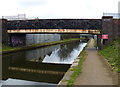
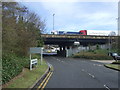
3
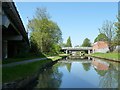
Perrywell Road bridge, Tame Valley canal
Immediately north of the M6 motorway.
Image: © Christine Johnstone
Taken: 5 May 2018
0.04 miles
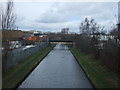
7
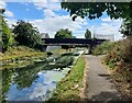
Moor Lane Bridge crossing the Tame Valley Canal
Image: © Mat Fascione
Taken: 31 Jul 2022
0.07 miles
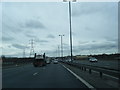
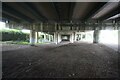
10
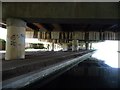
A boater's view of the M6 motorway bridge at Witton
The Tame Valley canal opened in 1844, the motorway above it in 1970.
Image: © Christine Johnstone
Taken: 5 May 2018
0.09 miles