IMAGES TAKEN NEAR TO
Union Way, B6 7FH
Introduction
This page details the photographs taken nearby to Union Way, B6 7FH by members of the Geograph project.
The Geograph project started in 2005 with the aim of publishing, organising and preserving representative images for every square kilometre of Great Britain, Ireland and the Isle of Man.

There are currently over 7.5m images from over14,400 individuals and you can help contribute to the project by visiting https://www.geograph.org.uk
Image Map
Images are licensed for reuse under creativecommons.org/licenses/by-sa/2.0
Notes
- Clicking on the map will re-center to the selected point.
- The higher the marker number, the further away the image location is from the centre of the postcode.
Image Listing (165 Images Found)
Images are licensed for reuse under creativecommons.org/licenses/by-sa/2.0
Image
Details
Distance
1
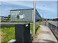
Urban Express Park, Aston
The park sits in the angle of Lichfield Road, right, and Waterworks Street, left. Grey sheds are 'New industrial & warehouse units to let'. The location is near the M6 at Junction 6, Spaghetti Junction.
Image reference: 7511877
Image: © Robin Stott
Taken: 29 May 2023
0.03 miles
2
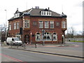
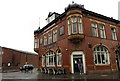
The King Edward VII
The King Edward VII pub which stands on the junction of Aston Hall Road with Lichfield Road.
Image: © Philip Halling
Taken: 2 Mar 2009
0.05 miles
3

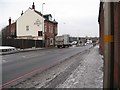
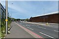
East end of Aston Hall Road, Aston
Passing through an industrial area off Lichfield Road.
Image: © Richard Vince
Taken: 19 Nov 2022
0.05 miles
4
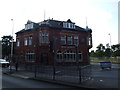
King Edward VII no more - Aston, Birmingham
A view from the south-west of the former King Edward VII pub, dating from 1902, at the junction of Lichfield Road and Aston Hall Road, now demolished. In March 2015 there were plans to demolish this pub to allow remodelling of the road junction for the future building of an industrial park. City councillors were mistakenly told that the building, of considerable heritage value, was standing empty and derelict when it was in fact a thriving concern with caring owners. Negotiations were entered into between the owners and the City Council, who offered a move to the nearby Aston Tavern, which had been standing empty and derelict for a number of years. Agreement was reached and fixtures and fittings were moved from this pub to the Aston Tavern before the King Edward VII building was demolished in 2015. It has been said that had the pub stayed open, it would have been isolated after work on the junction had been carried out but it was a shame to see yet another of Birmingham's architectural heritage yield to the bulldozer when another solution might have been found. It seems demolition and development are not always the answer. Time taken 9.06 am GMT (Greenwich Mean Time).
Image: © Martin Richard Phelan
Taken: 12 Jan 2010
0.06 miles
5
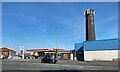
Fuel stop, Lichfield Road, Birmingham
The petrol station and shop were busy. The truncated blue-brick chimney bears the words BROS LTD. An enquiry to Birmingham History Forum was answered with an extract from an old street directory, indicating that this had been the works of Emery Bros Ltd., metal rollers (Victoria Mills). https://birminghamhistory.co.uk/forum/index.php
Photo number 7567196.
Image: © Robin Stott
Taken: 29 May 2023
0.06 miles
6
By VSN Steels Limited, Lichfield Road, Aston
VSN Steels describe themselves as 'Flame cutters' and 'Surface grinders'. Lichfield Road A5127 changes direction ahead, approaching the M6 Junction 6.
Image reference: 7511998
Image: © Robin Stott
Taken: 29 May 2023
0.06 miles
7
The King Edward VII on Lichfield Road
Image: © Steve Daniels
Taken: 22 May 2014
0.06 miles
9
Lichfield Road (A5127), Aston
Looking towards Spaghetti Junction from its junction with Aston Hall Road.
Image: © Richard Vince
Taken: 19 Nov 2022
0.07 miles
10
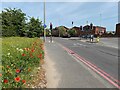
Aston Hall Road joins Lichfield Road, Aston
No Mow May has produced some good results here.
Image reference: 7512076
Image: © Robin Stott
Taken: 29 May 2023
0.07 miles