IMAGES TAKEN NEAR TO
Salstar Close, BIRMINGHAM, B6 4PP
Introduction
This page details the photographs taken nearby to Salstar Close, B6 4PP by members of the Geograph project.
The Geograph project started in 2005 with the aim of publishing, organising and preserving representative images for every square kilometre of Great Britain, Ireland and the Isle of Man.

There are currently over 7.5m images from over14,400 individuals and you can help contribute to the project by visiting https://www.geograph.org.uk
Image Map
Images are licensed for reuse under creativecommons.org/licenses/by-sa/2.0
Notes
- Clicking on the map will re-center to the selected point.
- The higher the marker number, the further away the image location is from the centre of the postcode.
Image Listing (24 Images Found)
Images are licensed for reuse under creativecommons.org/licenses/by-sa/2.0
Image
Details
Distance
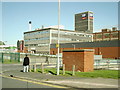
2
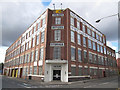
Former Telsen Electric Company Ltd building
This building was used as a factory producing wireless broadcast receivers, components and construction kits for Telsen Electric company in 1930's in Aston area of Birmingham. Presently it is a multi-unit industrial centre called "The Telsen Industrial Centre".
Image: © user
Taken: 17 Sep 2011
0.17 miles
3
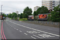
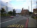
High Street, Newtown
Not really anybody's idea of a High Street, this is a stretch of the A34 heading into central Birmingham.
Image: © Stephen McKay
Taken: 27 May 2017
0.18 miles
4
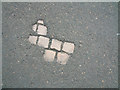
Cobbles beneath the surface of Bracebridge Street
Image: © Jeff Tomlinson
Taken: 2 Jun 2002
0.19 miles
5
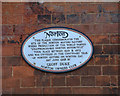
Norton Factory Plaque
Plaque on the wall of the T A Savery & Co Ltd, Newcomen Works, Bracebridge Street.
Image: © Jeff Tomlinson
Taken: 2 Jun 2002
0.19 miles
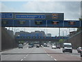
6
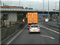
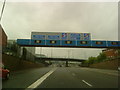
Aston Expressway, Aston Bridge
The slip road to the northbound Aston Expressway (A38M) passes under the A5127 at Aston Bridge.
Image: © David Dixon
Taken: 21 Dec 2012
0.19 miles
7
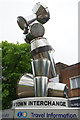
Mondobongo
This artwork was designed by Renn & Thacker Partnership LLP in 2004 for Centro. It features percussion instruments from around the world and is located close to the Drum Arts Centre.
Image: © Stephen McKay
Taken: 27 May 2017
0.19 miles
8
Southbound carriageway of High Street, Newtown
High Street, Newtown, is part of the A34, and as such is now a dual carriageway with three lanes in each direction (the northbound carriageway is at a slightly higher level, hidden by the foliage in the central reservation on the right). The rather impressive building just to the right of centre is the Bartons Arms, a large pub that was once a place to go for live jazz, but in more recent times has been associated with the goth scene (I seem to recall hearing of it hosting a trad goth night in its large upstairs function room around 2005).
Image: © Richard Vince
Taken: 26 Oct 2013
0.20 miles
9
A38(M) For Birmingham - Near The End, Birmingham Skyline
Image: © Roy Hughes
Taken: 6 May 2009
0.21 miles
10
The HP Sauce factory
Photograph take from Thomas Street looking across the Aston Expressway to the HP Sauce factory.
Image: © Carl Baker
Taken: 9 Oct 2006
0.21 miles