IMAGES TAKEN NEAR TO
Chester Street, BIRMINGHAM, B6 4AH
Introduction
This page details the photographs taken nearby to Chester Street, B6 4AH by members of the Geograph project.
The Geograph project started in 2005 with the aim of publishing, organising and preserving representative images for every square kilometre of Great Britain, Ireland and the Isle of Man.

There are currently over 7.5m images from over14,400 individuals and you can help contribute to the project by visiting https://www.geograph.org.uk
Image Map (Loading...)


Getting Data...Please wait
Leaflet Map data © OpenStreetMap
Images are licensed for reuse under creativecommons.org/licenses/by-sa/2.0
Notes
- Clicking on the map will re-center to the selected point.
- The higher the marker number, the further away the image location is from the centre of the postcode.
Image Listing (101 Images Found)
Images are licensed for reuse under creativecommons.org/licenses/by-sa/2.0
Image
Details
Distance
1
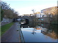
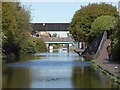
Birmingham & Fazeley Canal towards Evans Mill Basin Bridge
Image: © Ian S
Taken: 25 Jul 2021
0.08 miles
2
Birmingham & Fazeley Canal towards Evans Mill Basin Bridge
Image: © Ian S
Taken: 25 Jul 2021
0.08 miles
4
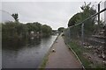
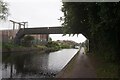
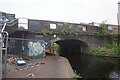
Birmingham & Fazeley Canal looking towards Rocky Lane
The black bridge carries electricity cables from the large substation out of sight on the left. The bridge in the background is Rocky Lane. The substation includes a part demolished building with an exposed white glazed internal wall with tall arched windows. I believe this is what is left of Aston Manor Power Station that was opened in 1903 and extended in 1906 and 1908.
Image: © Chris Allen
Taken: 2 Oct 2019
0.09 miles
5
Works footbridge over the Birmingham & Fazeley Canal
Image: © Ian S
Taken: 25 Jul 2021
0.09 miles
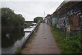
6
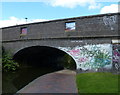
Avenue Road Bridge on the Birmingham & Fazeley Canal
In the Aston area of Birmingham.
Image: © Mat Fascione
Taken: 27 Sep 2015
0.09 miles
7
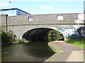
Birmingham & Fazeley Canal - Avenue Road Bridge
Image: © Chris Allen
Taken: 2 Oct 2019
0.09 miles
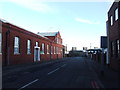
8
Birmingham & Fazeley Canal at Avenue Road Bridge
Image: © Ian S
Taken: 25 Jul 2021
0.09 miles
9
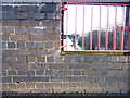
OS benchmark - Aston, Avenue Road bridge
An OS cutmark on the original brick parapet of the canal bridge, immediately adjacent to the 'fire door' opening that was used as a means of access to allow fire fighters to take water from the canal if required. The mark was originally levelled at 102.1m above Ordnance Datum Newlyn.
Image: © Richard Law
Taken: 28 Feb 2017
0.09 miles