IMAGES TAKEN NEAR TO
Broadway Avenue, HALESOWEN, B63 4RD
Introduction
This page details the photographs taken nearby to Broadway Avenue, B63 4RD by members of the Geograph project.
The Geograph project started in 2005 with the aim of publishing, organising and preserving representative images for every square kilometre of Great Britain, Ireland and the Isle of Man.

There are currently over 7.5m images from over14,400 individuals and you can help contribute to the project by visiting https://www.geograph.org.uk
Image Map
Images are licensed for reuse under creativecommons.org/licenses/by-sa/2.0
Notes
- Clicking on the map will re-center to the selected point.
- The higher the marker number, the further away the image location is from the centre of the postcode.
Image Listing (10 Images Found)
Images are licensed for reuse under creativecommons.org/licenses/by-sa/2.0
Image
Details
Distance
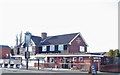
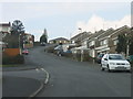
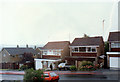
2
Halesowen, Broadway Avenue.
The A456 Manor Way runs alongside Broadway Avenue at this point.
Image: © Roy Hughes
Taken: 5 Mar 2009
0.04 miles
5
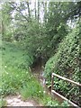
River Stour upstream of the Halesowen Bypass
Image: © John M
Taken: 18 May 2008
0.20 miles
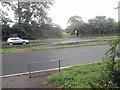
6
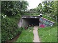
River Stour passing under the Halesowen Bypass
At this point the river enters the urban Black Country and historically was put to work in the forges and mills.
Image: © John M
Taken: 18 May 2008
0.20 miles
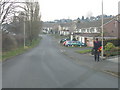
7
Halesowen, Pershore Road
Blakedown Road leads to the left.
Image: © Roy Hughes
Taken: 5 Mar 2009
0.20 miles
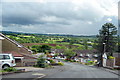
8
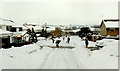
Halesowen Pershore Road, Summer Lightning 1989
Image: © Roy Hughes
Taken: Unknown
0.22 miles
9

Halesowen, Rainbow Over Pershore Road October 1985
Image: © Roy Hughes
Taken: Unknown
0.23 miles