IMAGES TAKEN NEAR TO
Greenbush Drive, HALESOWEN, B63 3TL
Introduction
This page details the photographs taken nearby to Greenbush Drive, B63 3TL by members of the Geograph project.
The Geograph project started in 2005 with the aim of publishing, organising and preserving representative images for every square kilometre of Great Britain, Ireland and the Isle of Man.

There are currently over 7.5m images from over14,400 individuals and you can help contribute to the project by visiting https://www.geograph.org.uk
Image Map
Images are licensed for reuse under creativecommons.org/licenses/by-sa/2.0
Notes
- Clicking on the map will re-center to the selected point.
- The higher the marker number, the further away the image location is from the centre of the postcode.
Image Listing (7 Images Found)
Images are licensed for reuse under creativecommons.org/licenses/by-sa/2.0
Image
Details
Distance
1
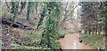
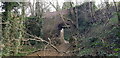
River Stour off Shelah Road
Here the Stour runs in a short but deep ravine which is a haven for wildlife. It is difficult to get down to the river. Evidence of the industrial past is clear. The slope is strewn with old junk and must have been used as an informal rubbish tip. Moreover, the 'soil', which is visible in places, seems to be almost pure coal waste, unsurprising given the hamlet placename (The Furnace) and the proximity of several collieries.
Image: © Paul Collins
Taken: 4 Mar 2022
0.22 miles
2
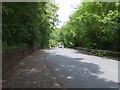
Shelah Road
A quiet road in Halesowen.
Image: © Gordon Griffiths
Taken: 24 May 2007
0.22 miles
3
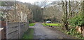
Footpath formerly Shelah Road and Tramway
This lane was formerly part of Shelah Road but this eastern section was bypassed in the latter half of the twentieth century and now serves merely as cul-de-sac access to a few houses and as a public footpath. It crosses the River Stour on a tall narrow arch bridge. I think that before it was Shelah Road, it was originally built as a tramway to link Old Hawn (later Hawne) Colliery with the canal. The colliery operated from about 1834 to 1902.
Image: © Paul Collins
Taken: 4 Mar 2022
0.22 miles
4
Footpath formerly Shelah Road and Tramway
This lane was formerly part of Shelah Road but this eastern section was bypassed in the latter half of the twentieth century and now serves merely as cul-de-sac access to a few houses and as a public footpath. It crosses the River Stour on a tall narrow arch bridge. I think that before it was Shelah Road, it was originally built as a tramway to link Old Hawn (later Hawne) Colliery with the canal. The colliery operated from about 1834 to 1902.
Image: © Paul Collins
Taken: 4 Mar 2022
0.24 miles
5
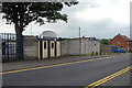
Turnstiles at 'The Yeltz'
'The Yeltz' being the alternative name to Halesowen Town FC.
Image: © Row17
Taken: 4 Jul 2009
0.24 miles
6
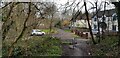
Former Tramway Bridge over River Stour
This lane this bridge carries was formerly part of Shelah Road but this eastern section was bypassed in the latter half of the twentieth century and now serves merely as cul-de-sac access to a few houses and as a public footpath. Here it crosses the River Stour which is in a deep ravine. I think that before it was Shelah Road, it was originally built as a tramway to link Old Hawn (later Hawne) Colliery with the canal. The colliery operated from about 1834 to 1902.
Image: © Paul Collins
Taken: 4 Mar 2022
0.24 miles
7
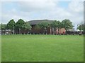
Halesowen College
Viewed from Furnace Lane.
Image: © Gordon Griffiths
Taken: 24 May 2007
0.24 miles