IMAGES TAKEN NEAR TO
Overbury Close, HALESOWEN, B63 3DL
Introduction
This page details the photographs taken nearby to Overbury Close, B63 3DL by members of the Geograph project.
The Geograph project started in 2005 with the aim of publishing, organising and preserving representative images for every square kilometre of Great Britain, Ireland and the Isle of Man.

There are currently over 7.5m images from over14,400 individuals and you can help contribute to the project by visiting https://www.geograph.org.uk
Image Map
Images are licensed for reuse under creativecommons.org/licenses/by-sa/2.0
Notes
- Clicking on the map will re-center to the selected point.
- The higher the marker number, the further away the image location is from the centre of the postcode.
Image Listing (22 Images Found)
Images are licensed for reuse under creativecommons.org/licenses/by-sa/2.0
Image
Details
Distance
2
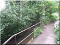
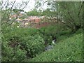
River Stour passing under the Halesowen Bypass
At this point the river enters the urban Black Country and historically was put to work in the forges and mills.
Image: © John M
Taken: 18 May 2008
0.09 miles
3
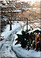
Halesowen Dogkennel Lane in the Snow 1990
Image: © Roy Hughes
Taken: 9 Dec 1990
0.09 miles
4
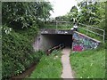
River Stour upstream of the Halesowen Bypass
Image: © John M
Taken: 18 May 2008
0.11 miles
5
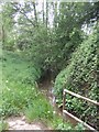
River Stour downstream of Dogkennel Lane
The 85 dwelling development bordering onto the river occupies the site of the former AA regional HQ, a four storey 1970s building. The AA have moved to a new office block in Oldbury.
Image: © John M
Taken: 18 May 2008
0.13 miles
6
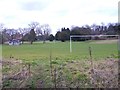
Sports Ground (With Pavilion)
This is adjacent to Somers Sports and Social Club.
Image: © Stephen Rogerson
Taken: 5 Mar 2015
0.15 miles
7
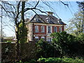
The Grange (Somers Sports & Social Club)
Formerly for staff of local forgemasters Walter Somers Ltd. The building was used by the Red Cross as an Auxiliary Hospital during the First World War.
Image: © John M
Taken: 8 Apr 2017
0.15 miles
10
Somers Sports and Social Club
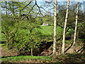
In the grounds of The Grange. The dip hides a small canal water feature that would have been used to collect ice in winter to be stored in the ice house. Image
Image: © John M
Taken: 8 Apr 2017
0.17 miles