IMAGES TAKEN NEAR TO
Timberdine Close, HALESOWEN, B63 2SP
Introduction
This page details the photographs taken nearby to Timberdine Close, B63 2SP by members of the Geograph project.
The Geograph project started in 2005 with the aim of publishing, organising and preserving representative images for every square kilometre of Great Britain, Ireland and the Isle of Man.

There are currently over 7.5m images from over14,400 individuals and you can help contribute to the project by visiting https://www.geograph.org.uk
Image Map
Images are licensed for reuse under creativecommons.org/licenses/by-sa/2.0
Notes
- Clicking on the map will re-center to the selected point.
- The higher the marker number, the further away the image location is from the centre of the postcode.
Image Listing (4 Images Found)
Images are licensed for reuse under creativecommons.org/licenses/by-sa/2.0
Image
Details
Distance
1
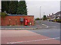
Furlong Lane Postbox
A Postbox on the corner of Hill Bank Road, Cradley.
Image: © Gordon Griffiths
Taken: 14 Oct 2009
0.11 miles
2
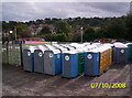
Portable toilets in Elliott Loohire depot
Image: © chris almond
Taken: 7 Oct 2008
0.18 miles
3
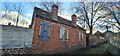
Old chain making shop between High Town and Furlong Lane / Hill Bank Road, Cradley
Located at the bottom of a garden in Ladysmith Road. As seen from the alleyway to the rear.
Image: © Leigh Cotterill
Taken: 22 Feb 2023
0.19 miles
4

High Town Ragged School Chapel, Cradley, Halesowen, West Midlands
As seen from the entrance to the alleyway leading to Colley Lane.
Image: © Leigh Cotterill
Taken: 22 Feb 2023
0.24 miles