IMAGES TAKEN NEAR TO
Hingley Road, HALESOWEN, B63 2RR
Introduction
This page details the photographs taken nearby to Hingley Road, B63 2RR by members of the Geograph project.
The Geograph project started in 2005 with the aim of publishing, organising and preserving representative images for every square kilometre of Great Britain, Ireland and the Isle of Man.

There are currently over 7.5m images from over14,400 individuals and you can help contribute to the project by visiting https://www.geograph.org.uk
Image Map
Images are licensed for reuse under creativecommons.org/licenses/by-sa/2.0
Notes
- Clicking on the map will re-center to the selected point.
- The higher the marker number, the further away the image location is from the centre of the postcode.
Image Listing (6 Images Found)
Images are licensed for reuse under creativecommons.org/licenses/by-sa/2.0
Image
Details
Distance
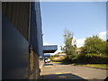
2
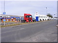
Trucks at The Hayes
The view on the A458 near Lye of Daf trucks at Imperial Commercials.
Image: © Gordon Griffiths
Taken: 20 Aug 2011
0.14 miles
3
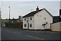
Park Lane Tavern
In Park Lane, Cradley
Image: © Geoff Gartside
Taken: 24 Mar 2007
0.15 miles
5
Gibbs Road View
The view down the Warehouse in Gibbs Road, Lye, Dudley.
Image: © Gordon Griffiths
Taken: 23 Jul 2014
0.23 miles
6
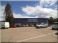
Country Baskets
The view of the Wholesale Warehouse in Gibbs Road, Lye, Dudley.
Image: © Gordon Griffiths
Taken: 5 Jun 2014
0.24 miles