IMAGES TAKEN NEAR TO
Chapelhouse Lane, HALESOWEN, B63 2JN
Introduction
This page details the photographs taken nearby to Chapelhouse Lane, B63 2JN by members of the Geograph project.
The Geograph project started in 2005 with the aim of publishing, organising and preserving representative images for every square kilometre of Great Britain, Ireland and the Isle of Man.

There are currently over 7.5m images from over14,400 individuals and you can help contribute to the project by visiting https://www.geograph.org.uk
Image Map
Images are licensed for reuse under creativecommons.org/licenses/by-sa/2.0
Notes
- Clicking on the map will re-center to the selected point.
- The higher the marker number, the further away the image location is from the centre of the postcode.
Image Listing (28 Images Found)
Images are licensed for reuse under creativecommons.org/licenses/by-sa/2.0
Image
Details
Distance
1
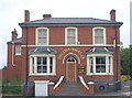
The Chainmaker, Cradley
Formerly the Talbot situated on the corner of Park Road and Colly Lane.
Image: © billypicks
Taken: 28 Jun 2008
0.06 miles
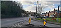
2
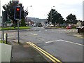
Junction between Colley Gate, Colley Lane and Chapel House Lane
Image: © Stephen Rogerson
Taken: 17 Feb 2017
0.07 miles
3
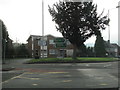
Colley Lane Junction With Colley Gate Cradley
Image: © Roy Hughes
Taken: 11 Jan 2018
0.08 miles
4
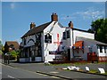
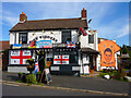
The Widdlers
A England flag on the side when the World Cup was on.
Image: © Stephen Rogerson
Taken: 13 Jun 2014
0.09 miles
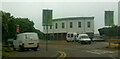
6
Junction of Colley Gate, Colley Lane, Burfield Road and Chapel House Lane
"Rainbow Street" Nursery.
Formerly "The Chainmaker" public house and "The Talbot Hotel"
Former brewery fronting Burfield Road.
Image: © Leigh Cotterill
Taken: 23 Feb 2023
0.09 miles
7
Derelict shops, Corner of Colley Lane and Colley Gate
February 2023 part of a compulsory purchase by Dudley MBC and likely (hopefully) demolished soon for council housing.
Image: © Leigh Cotterill
Taken: 23 Feb 2023
0.10 miles
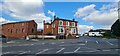
8
The Widders public house, Barrack Lane, Cradley, Halesowen
Formerly a Banks’s house called the Crown but was known locally as the Widows (it had been taken over after WW1 by two widowed sisters). It was later officially renamed as the Widders.
Image: © Leigh Cotterill
Taken: 23 Feb 2023
0.10 miles
9
The Widders, Barrack Lane, Cradley
Traditionally known as the "Crown Inn", located just off the A458 junction.
Image: © Oliver Mills
Taken: 17 Sep 2022
0.10 miles
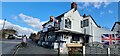
10
Junction of Park Road and Barrack Lane, Cradley, Halesowen
Image: © Leigh Cotterill
Taken: 23 Feb 2023
0.10 miles