IMAGES TAKEN NEAR TO
Drews Holloway, HALESOWEN, B63 2AG
Introduction
This page details the photographs taken nearby to Drews Holloway, B63 2AG by members of the Geograph project.
The Geograph project started in 2005 with the aim of publishing, organising and preserving representative images for every square kilometre of Great Britain, Ireland and the Isle of Man.

There are currently over 7.5m images from over14,400 individuals and you can help contribute to the project by visiting https://www.geograph.org.uk
Image Map
Images are licensed for reuse under creativecommons.org/licenses/by-sa/2.0
Notes
- Clicking on the map will re-center to the selected point.
- The higher the marker number, the further away the image location is from the centre of the postcode.
Image Listing (35 Images Found)
Images are licensed for reuse under creativecommons.org/licenses/by-sa/2.0
Image
Details
Distance
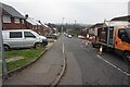
4
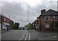
Windmill Hill, Halesowen
The crest of Windmill Hill, Halesowen. The pub on the right is the Round of Beef - one of two "meat-themed" pub names in this area
Image: © Noisar
Taken: 25 Apr 2019
0.07 miles
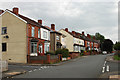
5
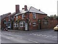
The Round of Beef
A Pub on Windmill Hill, Cradley.
Image: © Gordon Griffiths
Taken: 14 Oct 2009
0.08 miles