IMAGES TAKEN NEAR TO
B63 1LJ
Introduction
This page details the photographs taken nearby to B63 1LJ by members of the Geograph project.
The Geograph project started in 2005 with the aim of publishing, organising and preserving representative images for every square kilometre of Great Britain, Ireland and the Isle of Man.

There are currently over 7.5m images from over14,400 individuals and you can help contribute to the project by visiting https://www.geograph.org.uk
Image Map
Images are licensed for reuse under creativecommons.org/licenses/by-sa/2.0
Notes
- Clicking on the map will re-center to the selected point.
- The higher the marker number, the further away the image location is from the centre of the postcode.
Image Listing (4 Images Found)
Images are licensed for reuse under creativecommons.org/licenses/by-sa/2.0
Image
Details
Distance
1
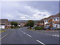
Portsdown Road View
The view off Portsdown Road towards Turner's Hill Dudley the highest point in the West Midlands.
Image: © Gordon Griffiths
Taken: 27 Aug 2011
0.10 miles
2
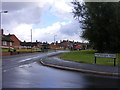
Portsdown Road Junction
The view off Portsdown Road down Rosemary Road near Halesowen.
Image: © Gordon Griffiths
Taken: 27 Aug 2011
0.11 miles
3
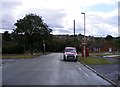
Bassnage Road
The view down the Halesowen road near Leebank Road.
Image: © Gordon Griffiths
Taken: 27 Aug 2011
0.17 miles
4
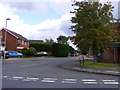
Mendip Road
The view off Portsdown Road near Halesowen.
Image: © Gordon Griffiths
Taken: 27 Aug 2011
0.21 miles