IMAGES TAKEN NEAR TO
Masters Lane, HALESOWEN, B62 9HE
Introduction
This page details the photographs taken nearby to Masters Lane, B62 9HE by members of the Geograph project.
The Geograph project started in 2005 with the aim of publishing, organising and preserving representative images for every square kilometre of Great Britain, Ireland and the Isle of Man.

There are currently over 7.5m images from over14,400 individuals and you can help contribute to the project by visiting https://www.geograph.org.uk
Image Map
Images are licensed for reuse under creativecommons.org/licenses/by-sa/2.0
Notes
- Clicking on the map will re-center to the selected point.
- The higher the marker number, the further away the image location is from the centre of the postcode.
Image Listing (17 Images Found)
Images are licensed for reuse under creativecommons.org/licenses/by-sa/2.0
Image
Details
Distance
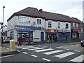
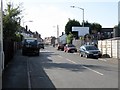
3

Junction of Belgrave and Beaumont Roads
Beaumont Road is the road crossing at the 'T' junction.
Image: © Peter Whatley
Taken: 9 Oct 2008
0.11 miles
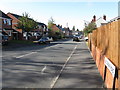
4
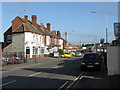
Nimmings Lane
The B4169 on its way toward Rowley Regis. A local contributor advises that this road is called Nimmings Lane, though the A to Z for Birmingham shows it as Nimmings Road.
Image: © Peter Whatley
Taken: 9 Oct 2008
0.11 miles
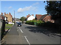
8
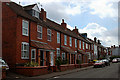
Houses in Beaumont Road
Two of my late sons schoolmates lived in one of these houses - but I'm not going to tell you which one.
Image: © Row17
Taken: 11 Jun 2009
0.17 miles
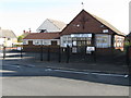
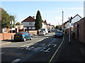
9
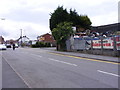
Halesowen Scrapyard
The view in Nimmings Road Rowley Regis.
Image: © Gordon Griffiths
Taken: 28 May 2011
0.17 miles