IMAGES TAKEN NEAR TO
Vicarage Road, HALESOWEN, B62 8HU
Introduction
This page details the photographs taken nearby to Vicarage Road, B62 8HU by members of the Geograph project.
The Geograph project started in 2005 with the aim of publishing, organising and preserving representative images for every square kilometre of Great Britain, Ireland and the Isle of Man.

There are currently over 7.5m images from over14,400 individuals and you can help contribute to the project by visiting https://www.geograph.org.uk
Image Map
Images are licensed for reuse under creativecommons.org/licenses/by-sa/2.0
Notes
- Clicking on the map will re-center to the selected point.
- The higher the marker number, the further away the image location is from the centre of the postcode.
Image Listing (20 Images Found)
Images are licensed for reuse under creativecommons.org/licenses/by-sa/2.0
Image
Details
Distance
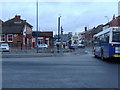
5
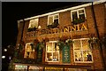
The Britannia public house
Wetherspoons pub on Halesowen Street, Blackheath.
Image: © Ian S
Taken: 15 Dec 2021
0.18 miles
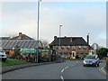
8
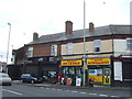
Basra Superstore & Off Licence, 71 Halesowen Street, Blackheath, Rowley Regis
Located on the corner of Halesowen Street and Cocksheds Lane, this is a local convenience store with off-licence.
Image: © P L Chadwick
Taken: 11 May 2014
0.22 miles
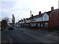
9
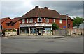
Shops on Long Lane, Halesowen
Showing position of Postbox No. B62 133.
See Image] for postbox.
Image: © JThomas
Taken: 8 Jun 2019
0.22 miles