IMAGES TAKEN NEAR TO
Lickey Grange, BROMSGROVE, B60 1NP
Introduction
This page details the photographs taken nearby to Lickey Grange, B60 1NP by members of the Geograph project.
The Geograph project started in 2005 with the aim of publishing, organising and preserving representative images for every square kilometre of Great Britain, Ireland and the Isle of Man.

There are currently over 7.5m images from over14,400 individuals and you can help contribute to the project by visiting https://www.geograph.org.uk
Image Map
Images are licensed for reuse under creativecommons.org/licenses/by-sa/2.0
Notes
- Clicking on the map will re-center to the selected point.
- The higher the marker number, the further away the image location is from the centre of the postcode.
Image Listing (25 Images Found)
Images are licensed for reuse under creativecommons.org/licenses/by-sa/2.0
Image
Details
Distance
1
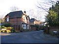
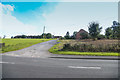
Lickey Grange - Entrance to Site of Lickey Grange
The road of Lickey Grange is off the Old Birmingham Road ( B4096). The properties were built on the site of what was Lickey Grange. The Grange was the former home of Herbert (Lord) Austin who founded the Austin Motor Car Company at Longbridge. Lord Austin is buried, with his wife, at the nearby Lickey Church (SO994753) After his death the property and grounds were taken over in 1953 by the Birmingham Royal Institute for the Blind. After they left the Grange and outbuildings were converted in houses and apartments.
Image: © Roy Hughes
Taken: 28 Dec 2008
0.01 miles

3
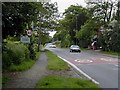
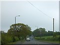
Old Birmingham Road
B4096, a rather busy road for a Sunday afternoon, but it does give access to the Lickey Hills and an exit from the SW Birmingham conurbation.
Image: © Martin Wilson
Taken: 4 Jun 2006
0.05 miles
4

Marlbrook Old Birmingham Road First Snow of Winter
Image: © Roy Hughes
Taken: 8 Dec 2017
0.08 miles
5
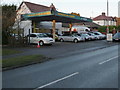
Graceland Garage
Locals will remember this as Hillside Garage, the garage/filling station owned and run by Les Morris. The pumps went first then after he retired it was taken on by an "Elvis" fan. Rumour has it that one night over a recent Christmas holiday a passing motorist called out the police because of "a drunken reveller playing a guitar on the roof".
Image: © Mike Dodman
Taken: 6 Dec 2008
0.10 miles
7
Driveway to Rainbows Farm
Although shown on the map as Firs Farm, to locals this has always been known as Rainbows Farm (from the family who have lived there for many years). As of October 2016, the farm is in the process of being sold. Might this scene be very different in a few years from now? No-one knows.
As David Smith Image said in 2013 there is "farmland between Marlbrook and Lickey." Will that remain?
See also Roy Hughes' photo Image showing the same stretch of the Old Birmingham Road.
Image: © Mike Dodman
Taken: 4 Oct 2016
0.12 miles
8
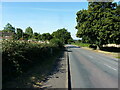
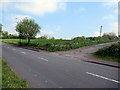
Farmland between Marlbrook and Lickey
For a short distance, the B4096 passes through farmland between the villages. It's not all built up.
Image: © David Smith
Taken: 21 May 2013
0.12 miles
9
Entrance to Firs Farm (aka Rainbow's Farm) off Old Birmingham Road
Image: © Roy Hughes
Taken: 4 May 2020
0.12 miles
10

Replacing Water Mains on Old Birmingham Road Lickey
Image: © Roy Hughes
Taken: 22 May 2020
0.14 miles