IMAGES TAKEN NEAR TO
Digbeth, BIRMINGHAM, B5 6BH
Introduction
This page details the photographs taken nearby to Digbeth, B5 6BH by members of the Geograph project.
The Geograph project started in 2005 with the aim of publishing, organising and preserving representative images for every square kilometre of Great Britain, Ireland and the Isle of Man.

There are currently over 7.5m images from over14,400 individuals and you can help contribute to the project by visiting https://www.geograph.org.uk
Image Map (Loading...)


Getting Data...Please wait
Leaflet Map data © OpenStreetMap
Images are licensed for reuse under creativecommons.org/licenses/by-sa/2.0
Notes
- Clicking on the map will re-center to the selected point.
- The higher the marker number, the further away the image location is from the centre of the postcode.
Image Listing (1250 Images Found)
Images are licensed for reuse under creativecommons.org/licenses/by-sa/2.0
Image
Details
Distance
1
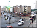
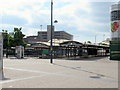
Park Street and Moat Lane, Digbeth, Birmingham
Viewed from the Selfridges building at the Bullring. The green building on the far right is the Birmingham market building.
Image: © Jonathan Billinger
Taken: 9 Nov 2007
0.00 miles
2
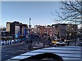
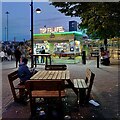
Digbeth at dusk
Digbeth is generally believed to derive its name from 'dyke path'; see this Wikipedia article on the district here https://en.wikipedia.org/wiki/Digbeth .
The street named Digbeth descends the hill from St Martin's in the Bull Ring, the parish church of old Birmingham (which is just off to the right of this picture), in a south-eastwards direction towards the River Rea and Deritend High Street. It was one of the first areas of the city to be settled; the Old Crown Inn on Deritend High Street, not visible here, is a rare survivor of the medieval, timber-framed Birmingham.
The picture was taken from the walkway in front of Selfridges, part of the Bull Ring shopping centre.
Image: © A J Paxton
Taken: 6 Feb 2022
0.01 miles
4

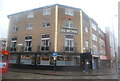
St Martin's in the Bull Ring, Birmingham
Seen here from Moat Lane (a.k.a. the A4100). The Bull Ring Open Market can be glimpsed on the left.
Image: © David Hallam-Jones
Taken: 23 Feb 2019
0.01 miles
5

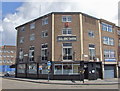
Edgbaston Street and market in Birmingham
At The Bullring, this is the eastern end of the pedestrianised Edgbaston Street, looking east towards Moat Lane. The Bullring Open Market is on the right.
Image: © Roger Kidd
Taken: 20 Jan 2022
0.02 miles
7
Birmingham 10.00am Friday 15th May 2020 (3)
Image: © Roy Hughes
Taken: 15 May 2020
0.02 miles
8
Top Felafel
After hours in Birmingham markets...
Image: © A J Paxton
Taken: 5 Oct 2024
0.02 miles
9
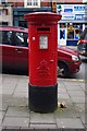
Edward VIII postbox, Digbeth, Birmingham
A postbox is something that most of us take for granted and rarely give a second glance, unless we have a letter to post. But stop and look at this one closely and you will discover that this is a very rare one which dates from the brief reign of King Edward VIII in 1936. He became king following the death of his father King George V and was never crowned because he abdicated the same year to marry Wallis Simpson. About 161 pillar boxes with Edward VIII's cipher were installed of which about 130 are thought to remain. They, along with surviving postage stamps, are some of the few reminders of this reign. Test coins with his portrait were struck but never issued.
Postbox number:- B5 22. Post code:- B5 5BD. Last collection:- 6.30 pm Monday to Friday; 12 noon Saturday.
Image
Image
Image: © P L Chadwick
Taken: 14 Mar 2015
0.02 miles
10
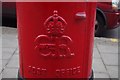
Edward VIII postbox - Royal Cipher, Digbeth, Birmingham
A close-up view of the Royal Cipher of King Edward VIII on this rare type of postbox, dating from 1936.
See:- Image
Image: © P L Chadwick
Taken: 14 Mar 2015
0.02 miles