IMAGES TAKEN NEAR TO
Kinwarton, ALCESTER, B49 6HA
Introduction
This page details the photographs taken nearby to B49 6HA by members of the Geograph project.
The Geograph project started in 2005 with the aim of publishing, organising and preserving representative images for every square kilometre of Great Britain, Ireland and the Isle of Man.

There are currently over 7.5m images from over14,400 individuals and you can help contribute to the project by visiting https://www.geograph.org.uk
Image Map
Images are licensed for reuse under creativecommons.org/licenses/by-sa/2.0
Notes
- Clicking on the map will re-center to the selected point.
- The higher the marker number, the further away the image location is from the centre of the postcode.
Image Listing (17 Images Found)
Images are licensed for reuse under creativecommons.org/licenses/by-sa/2.0
Image
Details
Distance
1

Alcester Captain's Hill Near Alcester Academy
Image: © Roy Hughes
Taken: 5 Apr 2016
0.12 miles
2
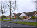
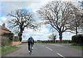
Modern Houses
These modern houses are on the north western outskirts of the small town of Alcester. The road is the B4089 to Great Alne known as Captains Hill.
Image: © Nigel Mykura
Taken: 15 Mar 2013
0.16 miles
3
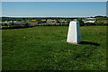
Trig point above Alcester
This trig point just to the north of Alcester has had a coat of paint since Richard Webb photographed it six years ago. The Arden Forest Industrial Estate can be seen in the background, see: Image
Image: © Philip Halling
Taken: 22 May 2010
0.16 miles
4
On the Arden Way & trig point NE of Alcester
Image: © Colin Park
Taken: 16 Jul 2022
0.16 miles
5
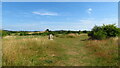
'You Go Your Way I'll Go Mine'
Three different long distance paths follow this footpath just to the north of Alcester: The Heart of England Way, The Arden Way and The Monarch's Way.
Image: © Philip Halling
Taken: 22 May 2010
0.18 miles
7
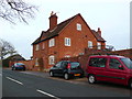
House near Kinwarton
This distinctive red brick house stands on its own on Captain's Hill the B4089 road running west out of Alcester towards great Alne
Image: © Nigel Mykura
Taken: 15 Mar 2013
0.18 miles
8
Elizabeth II postbox on the B4089, Kinwarton
Postbox No. B49 56.
See Image] for close up.
Image: © JThomas
Taken: 8 Apr 2017
0.20 miles
9
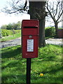
Close up, Elizabeth II postbox on the B4089, Kinwarton
Postbox No. B49 56.
See Image] for wider view.
Image: © JThomas
Taken: 8 Apr 2017
0.20 miles
10
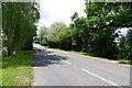
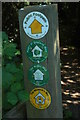
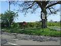
Captain's Hill, leading in to Alcester
The Monarch's Way joins at the yellow-topped post on the right, and follows the road in to Alcester
Image: © Tim Heaton
Taken: 22 Jun 2013
0.20 miles