IMAGES TAKEN NEAR TO
Digby Road, BIRMINGHAM, B46 3LP
Introduction
This page details the photographs taken nearby to Digby Road, B46 3LP by members of the Geograph project.
The Geograph project started in 2005 with the aim of publishing, organising and preserving representative images for every square kilometre of Great Britain, Ireland and the Isle of Man.

There are currently over 7.5m images from over14,400 individuals and you can help contribute to the project by visiting https://www.geograph.org.uk
Image Map
Images are licensed for reuse under creativecommons.org/licenses/by-sa/2.0
Notes
- Clicking on the map will re-center to the selected point.
- The higher the marker number, the further away the image location is from the centre of the postcode.
Image Listing (53 Images Found)
Images are licensed for reuse under creativecommons.org/licenses/by-sa/2.0
Image
Details
Distance
1
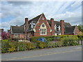
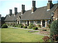
The Old School, Coleshill
The former town school, built in the early 1870s, extended in the late 1880s, and Grade II listed https://www.britishlistedbuildings.co.uk/101382108-the-old-school-coleshill#.WyilIadKiUk in August 2000.
Image: © Richard Law
Taken: 3 May 2018
0.14 miles
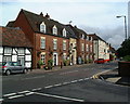
2
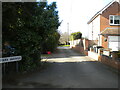
Park Avenue, Coleshill
A narrow residential cul de sac off Parkfield Road.
Image: © Richard Vince
Taken: 25 Feb 2022
0.14 miles
6
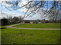
Cricket ground, Coleshill (1)
Looking from Parkfield Road towards the pavilion. On the horizon, the skyline of the northern part of Chelmsley Wood can just be glimpsed, complete with at least one high rise block of flats that may be in Kingshurst.
Image: © Richard Vince
Taken: 25 Feb 2022
0.16 miles
7
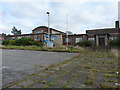
Former police station and courthouse
Fairly recently vacated by the long arm of the law, the building on the left was the police station, whilst the flat-roofed building on the right is the former Juvenile Court.
Update - as of early 2017, these buildings have been demolished, and the site is undergoing redevelopment for housing.
Image: © Richard Law
Taken: 24 Nov 2016
0.16 miles
8
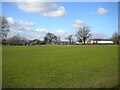
Cricket ground, Coleshill (2)
Looking from Parkfield Road towards the square (visible roped off in the distance).
Image: © Richard Vince
Taken: 25 Feb 2022
0.17 miles
9
The Coleshill Hotel High Street Coleshill
Image: © John A Lainchbury
Taken: 15 Jun 2007
0.18 miles
10
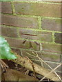
OS benchmark - Coleshill, former Juvenile Court
An OS cutmark on the front wall of a now-disused building that has formerly been the local Juvenile Court, and the town police station. It was originally levelled, probably in 1964, at 86.42m above Ordnance Datum Newlyn.
Update - as of March 2017, this mark has been destroyed, the former buildings on site have been cleared for housing development.
Image: © Richard Law
Taken: 24 Nov 2016
0.18 miles