IMAGES TAKEN NEAR TO
Attleboro Lane, BIRMINGHAM, B46 1SD
Introduction
This page details the photographs taken nearby to Attleboro Lane, B46 1SD by members of the Geograph project.
The Geograph project started in 2005 with the aim of publishing, organising and preserving representative images for every square kilometre of Great Britain, Ireland and the Isle of Man.

There are currently over 7.5m images from over14,400 individuals and you can help contribute to the project by visiting https://www.geograph.org.uk
Image Map
Images are licensed for reuse under creativecommons.org/licenses/by-sa/2.0
Notes
- Clicking on the map will re-center to the selected point.
- The higher the marker number, the further away the image location is from the centre of the postcode.
Image Listing (32 Images Found)
Images are licensed for reuse under creativecommons.org/licenses/by-sa/2.0
Image
Details
Distance
1
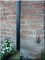
OS benchmark - Water Orton, Attleborough Farm
An OS cutmark on one of the converted barns at Attleboro(ugh) Farm; most recently levelled in 1965 at 95.893m above Ordnance Datum Newlyn, but it's been there a lot longer than that, as it is marked on maps from the 1900s.
Image: © Richard Law
Taken: 20 Dec 2016
0.01 miles
2

Noisy footpath
This idyllic footpath is one of the noisiest footpaths I have ever used. The other side of the hedge to the left and about 30 feet down is the M6 to M42 slip road.
Image: © Mark Walton
Taken: 28 Mar 2007
0.02 miles
3
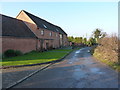
Attleborough Farm
Barn conversions at the former Attleborough Farm; the largest one is Oak Barn.
Image: © Richard Law
Taken: 20 Dec 2016
0.03 miles
4
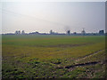
Towards Attleboro farm
Looking South West across the field to Attleboro farm from the point at where the public footpath leaves the short track making up its first 100 yards.
Image: © Mark Walton
Taken: 28 Mar 2007
0.04 miles
5

Slip road from M6 northbound to M42
Viewed from the footbridge over the M6 to M42. Vehicles on the right are going up the M42 North, vehicles on left will be using the M42 South.
Image: © Mark Walton
Taken: 28 Mar 2007
0.04 miles
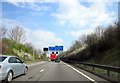
6

Parting of the ways, M6 junction 4a
Note that the M6 has regained its third lane even before the M42 south to M6 west connection bridge, a reflection of the original junction layout.
Image: © Peter Whatley
Taken: 11 Feb 2012
0.06 miles
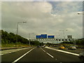
7
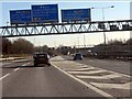
M6 motorway at junction 4a southbound
The critical decision point for southbound traffic for the London area. Along the M6 and M1 or the later M42/M40 route. Alternatively, get in lane for the M42 northbound. When first opened, this junction was a simple slip road to the M42 from the 3-lane M6, splitting into two around the corner after the junction. At that time the M40's extension to London remained to be completed, so the M42 was of largely local significance.
Image: © Peter Whatley
Taken: 11 Feb 2012
0.07 miles

9
M42 Sliproad From Junction 4a M6 Eastbound
Image: © Roy Hughes
Taken: 8 Apr 2015
0.10 miles