IMAGES TAKEN NEAR TO
Lyall Gardens, BIRMINGHAM, B45 9YW
Introduction
This page details the photographs taken nearby to Lyall Gardens, B45 9YW by members of the Geograph project.
The Geograph project started in 2005 with the aim of publishing, organising and preserving representative images for every square kilometre of Great Britain, Ireland and the Isle of Man.

There are currently over 7.5m images from over14,400 individuals and you can help contribute to the project by visiting https://www.geograph.org.uk
Image Map
Images are licensed for reuse under creativecommons.org/licenses/by-sa/2.0
Notes
- Clicking on the map will re-center to the selected point.
- The higher the marker number, the further away the image location is from the centre of the postcode.
Image Listing (7 Images Found)
Images are licensed for reuse under creativecommons.org/licenses/by-sa/2.0
Image
Details
Distance
1
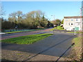
Boleyn Road joins New Inns Lane at Gannow Green
Image: © Richard Law
Taken: 20 Jan 2020
0.08 miles
3
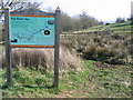
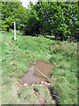
Notice Board at Source of River Rea
Image: © Roy Hughes
Taken: 20 Mar 2009
0.20 miles
4
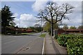
Ormond Road, Rubery
Ormond Road passing the Lickey Banker pub.
Image: © Philip Halling
Taken: 26 Apr 2018
0.22 miles
6
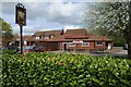
Lickey Banker
The Lickey Banker pu in Rubery
Image: © Philip Halling
Taken: 26 Apr 2018
0.22 miles
7
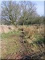
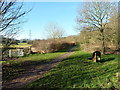
Source of Birmingham's River Rea.
This is the source of the River Rea on Windmill Hill, Frankley. Image
Image: © Roy Hughes
Taken: 20 Mar 2009
0.23 miles