IMAGES TAKEN NEAR TO
Cock Hill Lane, BIRMINGHAM, B45 9RU
Introduction
This page details the photographs taken nearby to Cock Hill Lane, B45 9RU by members of the Geograph project.
The Geograph project started in 2005 with the aim of publishing, organising and preserving representative images for every square kilometre of Great Britain, Ireland and the Isle of Man.

There are currently over 7.5m images from over14,400 individuals and you can help contribute to the project by visiting https://www.geograph.org.uk
Image Map
Images are licensed for reuse under creativecommons.org/licenses/by-sa/2.0
Notes
- Clicking on the map will re-center to the selected point.
- The higher the marker number, the further away the image location is from the centre of the postcode.
Image Listing (51 Images Found)
Images are licensed for reuse under creativecommons.org/licenses/by-sa/2.0
Image
Details
Distance
1
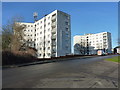
Rushmoor House flats, Cock Hill Lane
One of a series of 5 identical blocks of flats on Cock Hill Lane, Rubery. Redworth House is visible behind this one.
Image: © Richard Law
Taken: 20 Jan 2020
0.00 miles
2
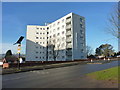
Redworth House flats, Cock Hill Lane
One of a series of 5 identical blocks rising up the hillside in Rubery.
Image: © Richard Law
Taken: 20 Jan 2020
0.04 miles
3
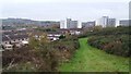
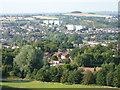
View From Rubery Hill
Rubery Hill is an outlier of the Lickey Hills and is public open space. It has been extensively quarried in the past and the housing estate seen to the left commemorates this, being Sandstone Avenue.
Image: © Paul Collins
Taken: 15 Nov 2017
0.07 miles
4
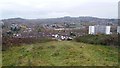
View From Rubery Hill
Rubery Hill is an outlier of the Lickey Hills and is public open space. It has been extensively quarried in the past and the housing estate nearest the camera commemorates this, being Sandstone Avenue. The hills in the distance are the Lickey Hills - Beacon Hill to the right and Rednal Hill to the left.
Image: © Paul Collins
Taken: 15 Nov 2017
0.08 miles
5
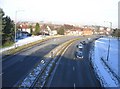
A38 Rubery by-Pass from Whettybridge Road bridge
The A38 as it leaves Rubery heading towards Longbridge Birmingham.
Image: © Roy Hughes
Taken: 6 Jan 2009
0.11 miles
6
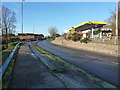
Petrol station on Cock Hill Lane
A Jet station, with petrol currently at £1.269 per litre, and diesel at £1.319
Image: © Richard Law
Taken: 20 Jan 2020
0.12 miles
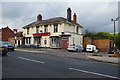
8
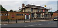
New Rose and Crown, Rubery
This pub appears to be closed for renovations, having had modern windows fitted and chimneys removed. But it seems that work has paused, with weeds growing and the site looking abandoned. See Image for a 2018 view.
Image: © Paul Collins
Taken: 7 Sep 2023
0.14 miles
9
New Rose & Crown (1), 217 New Road, Rubery near Birmingham
The exterior of this old public house, formerly a hotel, badly needs a repaint. In fact at first glance the place looked closed but it was in fact open. A facelift would probably attract new customers. It offers food but no real ale.
Image
Image
Image
Image: © P L Chadwick
Taken: 3 Nov 2018
0.14 miles
10
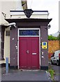
New Rose & Crown (3) - door, 217 New Road, Rubery near Birmingham
This public house used to be a hotel. The glass above the door has the name "Rose & Crown Hotel" in blue lettering on patterned glass.
Other photos, see:- Image
Image: © P L Chadwick
Taken: 3 Nov 2018
0.14 miles