IMAGES TAKEN NEAR TO
Cofton Church Lane, BIRMINGHAM, B45 8PS
Introduction
This page details the photographs taken nearby to Cofton Church Lane, B45 8PS by members of the Geograph project.
The Geograph project started in 2005 with the aim of publishing, organising and preserving representative images for every square kilometre of Great Britain, Ireland and the Isle of Man.

There are currently over 7.5m images from over14,400 individuals and you can help contribute to the project by visiting https://www.geograph.org.uk
Image Map
Images are licensed for reuse under creativecommons.org/licenses/by-sa/2.0
Notes
- Clicking on the map will re-center to the selected point.
- The higher the marker number, the further away the image location is from the centre of the postcode.
Image Listing (8 Images Found)
Images are licensed for reuse under creativecommons.org/licenses/by-sa/2.0
Image
Details
Distance
1
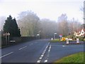
Cofton Church Road junction with B4120
Junction of Cofton Church Lane from Kendal End Road with Barnt Green Road ahead.
Image: © Roy Hughes
Taken: 14 Jan 2009
0.08 miles
2

Cofton Church Lane Junction at Kendal End
Image: © Roy Hughes
Taken: 4 May 2020
0.09 miles
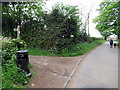
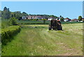
4
Warren Lane (bridleway), Kendal End
This bridleway skirts the southern end of Cofton Hill at Lickey Hills Country Park. The photo was taken from the junction with the B4120, looking south-west.
Image: © Phil Champion
Taken: 20 Feb 2006
0.15 miles
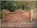
6
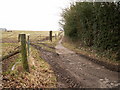
Bridleway from Cofton Church Lane
Looking north.
Image: © Phil Champion
Taken: 20 Feb 2006
0.21 miles
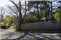
7
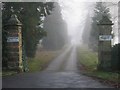
Cofton Hall, entrance gateway
Cofton Hall, just off Cofton Church Lane.
Image: © Roy Hughes
Taken: 14 Jan 2009
0.22 miles