IMAGES TAKEN NEAR TO
Hewell Road, BIRMINGHAM, B45 8NG
Introduction
This page details the photographs taken nearby to Hewell Road, B45 8NG by members of the Geograph project.
The Geograph project started in 2005 with the aim of publishing, organising and preserving representative images for every square kilometre of Great Britain, Ireland and the Isle of Man.

There are currently over 7.5m images from over14,400 individuals and you can help contribute to the project by visiting https://www.geograph.org.uk
Image Map
Images are licensed for reuse under creativecommons.org/licenses/by-sa/2.0
Notes
- Clicking on the map will re-center to the selected point.
- The higher the marker number, the further away the image location is from the centre of the postcode.
Image Listing (25 Images Found)
Images are licensed for reuse under creativecommons.org/licenses/by-sa/2.0
Image
Details
Distance
1
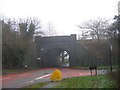
Bridge on B4120 under the Birmingham to Bristol railway line.
Image taken from Kendal End road with Bittell Road ahead and Fiery Hill Road entering from the right.
Image: © Roy Hughes
Taken: 14 Jan 2009
0.07 miles
2
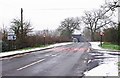
Kendal End Road (B4120) looking towards the railway bridge, Barnt Green
The railway bridge is in the distance. On the other side of the bridge, Kendal End Road becomes Bittell Road. The road on the right, in the foreground, is the drive to Barnt Green Inn.
Image: © P L Chadwick
Taken: 4 Feb 2012
0.08 miles
3
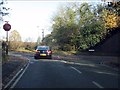
Fiery Hill Road meets the B4120
The junction signting is restricted by the railway bridge alongside Fiery Hill Road, hence the mirror on the far side of the junction.
Image: © Peter Whatley
Taken: 27 Nov 2011
0.09 miles
4
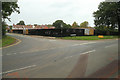
Fields turn into houses
Previously fields, this is another upmarket housing development being built in Barnt Green. The railway line runs along just behind my left shoulder.
Image: © Mike Dodman
Taken: 7 Oct 2016
0.09 miles
5
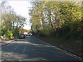
Long straight on Fiery Hill Road
The road runs dead straight alongside the Birmingham-Bristol main railway line.
Image: © Peter Whatley
Taken: 27 Nov 2011
0.10 miles
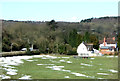
6
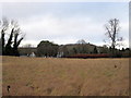
Barnt Green, Fiery Hill Road - Open Fields, For Now!
This open land in Barnt Green has been the subject of fierce local debate over plans to build 88 new homes. The proposal was voted through on 9 January 2012 despite 200 protesters turning up at the Council House. Image]
Image: © Roy Hughes
Taken: 10 Jan 2012
0.11 miles
7
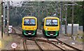
Class 323s Near Barnt Green
Class 323 electric multiple units Nos 323203 and 323222 on cross city services pass just to the north of Barnt Green station
Image: © Rob Newman
Taken: 22 Sep 2010
0.12 miles
8
Not just any field, this is a "bonfire" field
Every November, this field is the venue for Barnt Green scouts' very family-friendly bonfire, a major fund-raising activity to support their scouting activities. The same field is seen from (I assume) a railway carriage in Image
Image: © Mike Dodman
Taken: 7 Oct 2016
0.12 miles
10
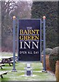
The Barnt Green Inn (2) - sign, 22 Kendal End Road, Barnt Green
The sign is in the front garden. The pub is named after the village where it is located.
Image
Image: © P L Chadwick
Taken: 4 Feb 2012
0.15 miles