IMAGES TAKEN NEAR TO
B45 8DQ
Introduction
This page details the photographs taken nearby to B45 8DQ by members of the Geograph project.
The Geograph project started in 2005 with the aim of publishing, organising and preserving representative images for every square kilometre of Great Britain, Ireland and the Isle of Man.

There are currently over 7.5m images from over14,400 individuals and you can help contribute to the project by visiting https://www.geograph.org.uk
Image Map
Images are licensed for reuse under creativecommons.org/licenses/by-sa/2.0
Notes
- Clicking on the map will re-center to the selected point.
- The higher the marker number, the further away the image location is from the centre of the postcode.
Image Listing (26 Images Found)
Images are licensed for reuse under creativecommons.org/licenses/by-sa/2.0
Image
Details
Distance
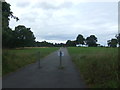
1
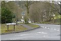
Ten Ashes Lane at the junction with Groveley Lane
Image: © Roger A Smith
Taken: 1 Apr 2008
0.07 miles
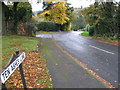
4
Groveley Lane B4096 near the junction with the B4120
Image: © Roger A Smith
Taken: 1 Apr 2008
0.08 miles
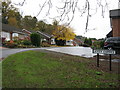
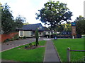
5
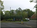
Roundabout at foot of Rose Hill, Lickey
The roundabout is unusual in having such a dense mass of bushes
Image: © David Smith
Taken: 21 May 2013
0.10 miles
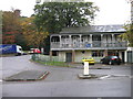
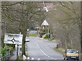
9
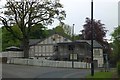
The Oak Tree inn, Lickey
Image: © David Smith
Taken: 21 May 2013
0.12 miles
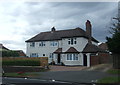
10
Oak Tree Inn, Cofton Hackett, Birmingham
Officially in Bromsgrove District, Worcestershire but really an outer suburb of Birmingham.
Image: © Jeff Gogarty
Taken: 16 Sep 2016
0.12 miles