IMAGES TAKEN NEAR TO
Boleyn Road, BIRMINGHAM, B45 0LU
Introduction
This page details the photographs taken nearby to Boleyn Road, B45 0LU by members of the Geograph project.
The Geograph project started in 2005 with the aim of publishing, organising and preserving representative images for every square kilometre of Great Britain, Ireland and the Isle of Man.

There are currently over 7.5m images from over14,400 individuals and you can help contribute to the project by visiting https://www.geograph.org.uk
Image Map
Images are licensed for reuse under creativecommons.org/licenses/by-sa/2.0
Notes
- Clicking on the map will re-center to the selected point.
- The higher the marker number, the further away the image location is from the centre of the postcode.
Image Listing (8 Images Found)
Images are licensed for reuse under creativecommons.org/licenses/by-sa/2.0
Image
Details
Distance
1
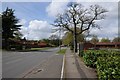
Ormond Road, Rubery
Ormond Road passing the Lickey Banker pub.
Image: © Philip Halling
Taken: 26 Apr 2018
0.08 miles
2
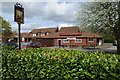
Lickey Banker
The Lickey Banker pu in Rubery
Image: © Philip Halling
Taken: 26 Apr 2018
0.11 miles
3
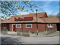
Lickey Banker Pub, Rubery "To Let"
Named after the "banking" locomotives which used to assist steam trains climb the steep incline, or bank, from Bromsgrove to Blackwell.
Image: © Roy Hughes
Taken: 21 Apr 2009
0.11 miles
4
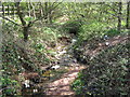
River Rea From Ormond Road, Rubery
Just about a mile from source, the Rea, still only a small stream, passes under Ormond Road, Rubery.
Image: © Roy Hughes
Taken: 21 Apr 2009
0.13 miles
5
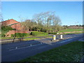
Edge of the housing in Frankley
This point (currently) marks the easternmost side of Frankley, which has seen more than its fair share of housing in the last 50 or 60 years. Maps of the 1930s show open countryside here, apart from the Halesowen Joint Line of the Midland & Great Western railway, which ran through the trees in mid-shot here, taking a route between Rubery/Northfield and Halesowen. This opened in the 1870s, but closed to public passenger traffic in 1919, although it continued to provide a service in and out of the Austin-Rover Longbridge car plant until the 1960s. The line closed completely in 1964.
Image: © Richard Law
Taken: 20 Jan 2020
0.14 miles
6
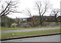
Edge of Housing Estate, Boleyn Road, Rubery
Image: © Geoff Gartside
Taken: 7 Apr 2007
0.16 miles
7
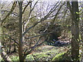
Old Railway Bridge
The bridge passes over the former Halesowen Railway.
Image: © Gordon Griffiths
Taken: 8 Apr 2011
0.22 miles
8
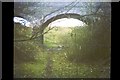
Footbridge across former Halesowen Railway
Just before reaching the M5 motorway, a footbridge crossed the trackbed of former railway line from Longbridge to Old Hill.
Image: © Michael Westley
Taken: Unknown
0.24 miles