IMAGES TAKEN NEAR TO
Crychan Close, BIRMINGHAM, B45 0JG
Introduction
This page details the photographs taken nearby to Crychan Close, B45 0JG by members of the Geograph project.
The Geograph project started in 2005 with the aim of publishing, organising and preserving representative images for every square kilometre of Great Britain, Ireland and the Isle of Man.

There are currently over 7.5m images from over14,400 individuals and you can help contribute to the project by visiting https://www.geograph.org.uk
Image Map
Images are licensed for reuse under creativecommons.org/licenses/by-sa/2.0
Notes
- Clicking on the map will re-center to the selected point.
- The higher the marker number, the further away the image location is from the centre of the postcode.
Image Listing (7 Images Found)
Images are licensed for reuse under creativecommons.org/licenses/by-sa/2.0
Image
Details
Distance
1
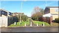
Path Linking Crychan Close with Hafren Close
This footpath is situated within a housing estate that looks to date mainly from the 1960s or 1970s. The path preserves the line of the access road to the long-gone Frogmill Farm.
Image: © Paul Collins
Taken: 11 Nov 2016
0.07 miles
2
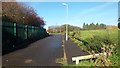
Road off Hafren Close
This short section of road is situated in the middle of a housing estate dating mostly (I guess) from the 1960s. It preserves the line of the lane that served as access to the long-gone Frogmill Farm. The road ends about 65 metres in front of the photographer at a metal fence (just visible). At that point the Rubery and Frankley Railway crossed the lane and can be walked (line of lamp posts just visible in front of distant conifers). The open land in the right of the view once contained a runaway siding for the railway. http://www.miac.org.uk/ruberyfrankley.html
Image: © Paul Collins
Taken: 11 Nov 2016
0.12 miles
3
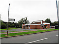
The Dingle Club
A social club for local residents.
Image: © Row17
Taken: 14 Aug 2013
0.14 miles
4
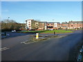
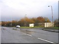
Roundabout at the junction of Tessall Lane and Hollymoor Way
The houses on the far side of the island were built around 2013/2014.
Image: © Richard Law
Taken: 20 Jan 2020
0.14 miles
5
Rubery Lane showing site of Halesowen Railway branch line crossing
The white fencing shows the site of the point where the Longbridge to Halesowen branch line crossed the road between Rubery and Longbridge stations.
Image: © Roy Hughes
Taken: 13 Jan 2009
0.19 miles
6
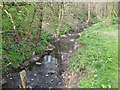
River Rea Just before it Passes Under Rubery Lane.
Image: © Roy Hughes
Taken: 6 Apr 2009
0.20 miles
7
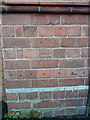
OS benchmark - Northfield, lodge at the (former) Hollymoor hospital site
Levelled in 1980 at 196.250m above Ordnance Datum Newlyn, this well-preserved benchmark sits on the lodge to the former mental hospital site.
Image: © Richard Law
Taken: 20 Jan 2020
0.24 miles