IMAGES TAKEN NEAR TO
Edmonton Avenue, BIRMINGHAM, B44 0XF
Introduction
This page details the photographs taken nearby to Edmonton Avenue, B44 0XF by members of the Geograph project.
The Geograph project started in 2005 with the aim of publishing, organising and preserving representative images for every square kilometre of Great Britain, Ireland and the Isle of Man.

There are currently over 7.5m images from over14,400 individuals and you can help contribute to the project by visiting https://www.geograph.org.uk
Image Map
Images are licensed for reuse under creativecommons.org/licenses/by-sa/2.0
Notes
- Clicking on the map will re-center to the selected point.
- The higher the marker number, the further away the image location is from the centre of the postcode.
Image Listing (7 Images Found)
Images are licensed for reuse under creativecommons.org/licenses/by-sa/2.0
Image
Details
Distance
1
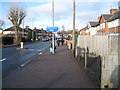
Finchley Road to the National Cycle Network route 535 - Kingstanding, North Birmingham
A view north-west along Finchley Road, Kingstanding, showing the access to National Cycle Network route no. 535. This route runs from Birmingham to join the 534 in Sutton Park. Details of this and other routes will be found on the Sustrans website. Time photo taken 11.24 am GMT (Greenwich Mean Time).
Image
Image: © Martin Richard Phelan
Taken: 15 Dec 2011
0.15 miles
2
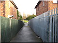
Finchley Road to the National Cycle Network route 535 again - Kingstanding, North Birmingham
Looking north-east on the alleyway from Finchley Road, Kingstanding to National Cycle Network route no. 535 on its way from Birmingham to join route no.534 in Sutton Park. Details of this and other routes will be found on the Sustrans website. Time photo taken 11.25 am GMT (Greenwich Mean Time).
Image
Image: © Martin Richard Phelan
Taken: 15 Dec 2011
0.18 miles
3
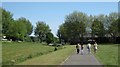
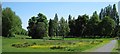
Finchley Park, near Homerton Road
Summer's day out in the city - improved recreation ground in Kingstanding
Image: © Michael Westley
Taken: 22 May 2010
0.18 miles
4
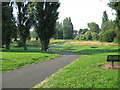
NCN route 535 - Birmingham, West Midlands
Through Finchley Park runs National Cycle Network route number 535 on its way from Sutton Coldfield to Birmingham - locally known as the North Birmingham Cycle/Walk Route. It is maintained by Birmingham City Council and Sustrans. This view is looking southwards towards College Road. Time taken 8.27 am BST (British Summer Time). Image
Image: © Martin Richard Phelan
Taken: 8 Aug 2013
0.20 miles
5
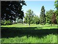
Finchley Park, Kingstanding
Wide grassy area, south of Kings Road, giving open space for pedestrians between housing estates
Image: © Michael Westley
Taken: 22 May 2010
0.21 miles
6
Finchley Park, Kingstanding
Open area between housing estates, just south of Kings Road
Image: © Michael Westley
Taken: 22 May 2010
0.21 miles
7
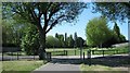
Homerton Road, Kingstanding
View of recreation ground, Finchley Park, from where Homerton Road crosses
Image: © Michael Westley
Taken: 22 May 2010
0.22 miles