IMAGES TAKEN NEAR TO
Hever Avenue, BIRMINGHAM, B44 0PP
Introduction
This page details the photographs taken nearby to Hever Avenue, B44 0PP by members of the Geograph project.
The Geograph project started in 2005 with the aim of publishing, organising and preserving representative images for every square kilometre of Great Britain, Ireland and the Isle of Man.

There are currently over 7.5m images from over14,400 individuals and you can help contribute to the project by visiting https://www.geograph.org.uk
Image Map
Images are licensed for reuse under creativecommons.org/licenses/by-sa/2.0
Notes
- Clicking on the map will re-center to the selected point.
- The higher the marker number, the further away the image location is from the centre of the postcode.
Image Listing (12 Images Found)
Images are licensed for reuse under creativecommons.org/licenses/by-sa/2.0
Image
Details
Distance
1
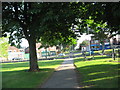
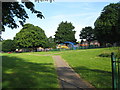
Looking north from Conker Island - Kingstanding, North Birmingham
The view north to Hurlingham Road from the path junction of the Conkers recreation ground, an island for leisure in Warren Farm Road, Kingstanding. Time photo taken 7.06 am BST (British Summer Time).
Image: © Martin Richard Phelan
Taken: 24 Jun 2014
0.11 miles
2
Danesbury Crescent - Hurlingham Road, Kingstanding
Image: © Alex McGregor
Taken: 5 Nov 2010
0.12 miles
3
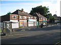
Shop local - Kingstanding, North Birmingham
Shops in a parade of shops on Warren Farm Road, Kingstanding. Time photo taken 07.11 am BST (British Summer Time).
Image: © Martin Richard Phelan
Taken: 24 Jun 2014
0.13 miles
4

Conker Island morning time - Kingstanding, North Birmingham
Situated where Warren Farm Road divides into two, Conker Island accompanies a parade of shops, a school and a health centre. Time photo taken 7.20 am BST (British Summer Time).
Image: © Martin Richard Phelan
Taken: 24 Jun 2014
0.14 miles
5
Conker Island is silent now - Kingstanding, North Birmingham
Visited on a before breakfast walk, Conker Island awaits the new days visitors.
Time photo taken 7.18 am BST (British Summer Time).
Image: © Martin Richard Phelan
Taken: 24 Jun 2014
0.14 miles
6
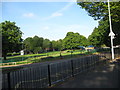
Conker Island in the early morning - Kingstanding, North Birmingham
A sunlit view westwards in the early morning over the Conker Island Recreation Ground on Warren Farm Road, Kingstanding. Time photo taken 7.15 am BST (British Summer Time).
Image: © Martin Richard Phelan
Taken: 24 Jun 2014
0.15 miles
7
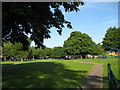
Early morning in the park - Kingstanding, North Birmingham
A view westwards across the Conker Island Recreation Ground in Warren Farm Road, Kingstanding. Time photo taken 7.15 am BST (British Summer Time).
Image: © Martin Richard Phelan
Taken: 24 Jun 2014
0.16 miles
8

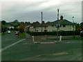
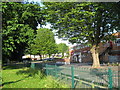
South from Conker Island - Kingstanding, North Birmingham
Looking south to Warren Farm Road from the path junction of the Conkers recreation ground, with the Warren Farm Treatment Centre just visible on the extreme right. Time photo taken 7.06 am BST (British Summer Time).
Image: © Martin Richard Phelan
Taken: 24 Jun 2014
0.17 miles
9
For former Forces - Kingstanding, North Birmingham
The Kingstanding Ex-Servicemens Club in Warren Farm Road, Kingstanding. Time photo taken 07.10 am BST (British Summer Time).
Image: © Martin Richard Phelan
Taken: 24 Jun 2014
0.19 miles
10

Westwards along Warren Farm Road - Kingstanding, North Birmingham
Looking westwards uphill along Warren Farm Road towards its junction with Hawthorn Road, from the boundary of the Conkers recreation ground. Time photo taken 7.08 am BST (British Summer Time).
Image: © Martin Richard Phelan
Taken: 24 Jun 2014
0.21 miles