IMAGES TAKEN NEAR TO
Ambury Way, BIRMINGHAM, B43 5JH
Introduction
This page details the photographs taken nearby to Ambury Way, B43 5JH by members of the Geograph project.
The Geograph project started in 2005 with the aim of publishing, organising and preserving representative images for every square kilometre of Great Britain, Ireland and the Isle of Man.

There are currently over 7.5m images from over14,400 individuals and you can help contribute to the project by visiting https://www.geograph.org.uk
Image Map
Images are licensed for reuse under creativecommons.org/licenses/by-sa/2.0
Notes
- Clicking on the map will re-center to the selected point.
- The higher the marker number, the further away the image location is from the centre of the postcode.
Image Listing (32 Images Found)
Images are licensed for reuse under creativecommons.org/licenses/by-sa/2.0
Image
Details
Distance
1
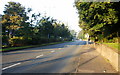
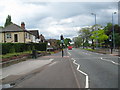
Looking down Newton Road, Great Barr
The view west down the eastbound carriageway as Newton Road descends from the A34 junction. Monksfield Avenue is nearby on the right. An early morning (it's 7.30am, Sunday) jogger is on the right, between the sign and the trees.
Image: © Jaggery
Taken: 13 Sep 2009
0.06 miles
2
Jayshaw Avenue, Great Barr
Viewed from Newton Road.
Image: © Jaggery
Taken: 13 Sep 2009
0.07 miles
3
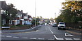
Newton Road A4041 3 - Great Barr, Birmingham
A view westwards on the A4041 Newton Road which runs from West Bromwich to the western edge of Sutton Park, where it joins the A452 Chester Road. This photo was taken at the junction of Newton Road with Fairyfield Avenue. The bus is the No 5 which runs from Sutton Coldfield to West Bromwich via New Oscott, Kingstanding, Queslett and Newton and is one of those services operated by National Express West Midlands. One of the advantages of living in the West Midlands is the superb public transport system. Time taken 1.53 pm BST (British Summer Time).
Image: © Martin Richard Phelan
Taken: 22 May 2016
0.07 miles
4
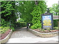
Way to the house - Red House, Great Barr, Sandwell
Standing on Newton Road, these gates are the way in to Red House Park, which has sports facilities, a community pavilion and car parking and a presently derelict mansion which is awaiting conversion. The Park is managed by Sandwell MBC (Metropolitan Borough Council). Time photo taken 1.54 pm BST (British Summer Time).
Image: © Martin Richard Phelan
Taken: 22 May 2016
0.11 miles
5
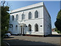
Fairyfield House, Great Barr
A rather magnificent late 18th century town house, now converted to flats, which was Grade II listed https://www.britishlistedbuildings.co.uk/101342670-fairyfield-house-fairyfield-court-charlemont-with-grove-vale-ward#.WzMw7NJKhPY as early as 1949.
Image: © Richard Law
Taken: 23 May 2018
0.11 miles
6
Information - Red House Park, Great Barr, Sandwell
An information board standing at the entrance to Red House Park giving details of local activities and necessary information for visitors to the park. Time photo taken 1.50 pm BST (British Summer Time).
Image: © Martin Richard Phelan
Taken: 22 May 2016
0.11 miles
7
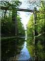
Boater's view of Chimney Bridge, Tame Valley canal
This Grade 2 listed structure shows how deep the cutting is. This footbridge, formerly a road bridge, carries Green Lane over the Tame Valley Canal and was built in 1844.
Image: © Christine Johnstone
Taken: 5 May 2018
0.14 miles
8
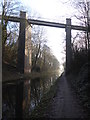
Tame Valley Canal - Chimney Bridge
This is a footbridge, formerly a road bridge, carrying Green Lane over the Tame Valley Canal. It is Listed Grade II but what I am seeing does not match the listing - "Single very shallow segmental arch. Sides, above girders, pierced to form lattice pattern of saltire crosses". I think it has been rebuilt.
Image: © Chris Allen
Taken: 19 Jan 2020
0.14 miles
9
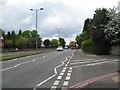
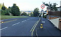
Newton Road A4041 2 - Great Barr, Sandwell, West Midlands
A view eastwards on the A4041 Newton Road which runs from West Bromwich to the western edge of Sutton Park, where it joins the A452 Chester Road. This photo was taken outside the entrance to Red House Park, a public park with parking and sports facilities, managed by Sandwell MBC (Metropolitan Borough Council). Time taken 1.52 pm BST (British Summer Time).
Image: © Martin Richard Phelan
Taken: 22 May 2016
0.15 miles
10
Monksfield Avenue, Great Barr
The view from the corner of Newton Road.
Image: © Jaggery
Taken: 13 Sep 2009
0.15 miles