IMAGES TAKEN NEAR TO
Walsall Road, BIRMINGHAM, B42 1SF
Introduction
This page details the photographs taken nearby to Walsall Road, B42 1SF by members of the Geograph project.
The Geograph project started in 2005 with the aim of publishing, organising and preserving representative images for every square kilometre of Great Britain, Ireland and the Isle of Man.

There are currently over 7.5m images from over14,400 individuals and you can help contribute to the project by visiting https://www.geograph.org.uk
Image Map
Images are licensed for reuse under creativecommons.org/licenses/by-sa/2.0
Notes
- Clicking on the map will re-center to the selected point.
- The higher the marker number, the further away the image location is from the centre of the postcode.
Image Listing (6 Images Found)
Images are licensed for reuse under creativecommons.org/licenses/by-sa/2.0
Image
Details
Distance
1
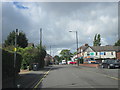
Walsall Road Four Oaks Approaching Shops
Image: © Roy Hughes
Taken: 11 Sep 2017
0.02 miles
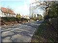
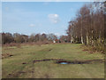
2
Gates to Streetly Lane, Sutton Park northeast
The vehicle gate will be for park maintenance. There are vehicle entrances for the public at Boldmere, Streetly and Four Oaks; there may be more.
Image: © Robin Stott
Taken: 6 Apr 2015
0.17 miles
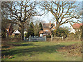
3
East on Streetly Lane, Four Oaks
On the right is the northern boundary to Sutton Park.
Image: © Robin Stott
Taken: 6 Apr 2015
0.18 miles
4
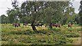
Exmoor Ponies in Sutton Park
Exmoor ponies were chosen in 1999 to maintain the heath and acid grassland habitat in Sutton Park.
Image: © Graham Jones
Taken: 10 Aug 2016
0.21 miles
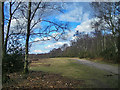
6
Track to Streetly Lane, Sutton Park northeast
Birch woodland is much in evidence in this northern part of the park, perhaps the aftermath of past felling or fire. The woodland on the right is named Mayor's Parlour. The TV mast is in Image Aerial photos show two tall masts within 100m of each other and a shorter mast in between.
Image: © Robin Stott
Taken: 6 Apr 2015
0.25 miles