IMAGES TAKEN NEAR TO
Old Lime Gardens, BIRMINGHAM, B38 9SG
Introduction
This page details the photographs taken nearby to Old Lime Gardens, B38 9SG by members of the Geograph project.
The Geograph project started in 2005 with the aim of publishing, organising and preserving representative images for every square kilometre of Great Britain, Ireland and the Isle of Man.

There are currently over 7.5m images from over14,400 individuals and you can help contribute to the project by visiting https://www.geograph.org.uk
Image Map
Images are licensed for reuse under creativecommons.org/licenses/by-sa/2.0
Notes
- Clicking on the map will re-center to the selected point.
- The higher the marker number, the further away the image location is from the centre of the postcode.
Image Listing (10 Images Found)
Images are licensed for reuse under creativecommons.org/licenses/by-sa/2.0
Image
Details
Distance
1
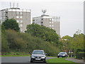
Branch Road flats, Hawkesley / West Heath
On southern outskirts of Birmingham, just off Redditch Road, two blocks of flats look out over the low hillsides Gay Hill, Forhill, and Headley Heath
Image: © Michael Westley
Taken: 12 Oct 2010
0.07 miles
2
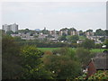
Hawkesley, residential housing
From Longdales Road, looking across leisure centre grounds, towards two blocks of flats on Branch Road.
On the skyline, directly ahead (to right of flats) is a green 'mound' - this is actually the small group of trees that is 'Frankley Beeches' 3 miles or so away.
Image: © Michael Westley
Taken: 12 Oct 2010
0.10 miles
3

Welcome to Hawkesley
Welcome sign on corner of Longdales Road and Shannon Road
Image: © Michael Westley
Taken: 12 Oct 2010
0.16 miles
4
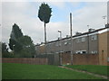
Listed Tree?
Lonely looking tall tree, between flats on housing estate off Green Lane Hawkesley (between Forth Grove and Ithon Grove). I believe that this street was built in the 1970s.
Image: © Michael Westley
Taken: 12 Oct 2010
0.16 miles
5
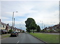
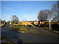
A441 Redditch Road Approaching Kings Norton Boundary
Image: © Roy Hughes
Taken: 31 May 2016
0.17 miles
6
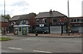
Shannon Road turning circle, Hawkesley
Despite the presence of this turning circle, buses terminating here on routes 27 and 35 run out of service via Longdales Road to a roundabout to turn round. As the bus stop is still in the turning circle (right), buses still pass through it, effectively using it as a large layby.
Image: © Richard Vince
Taken: 8 Dec 2012
0.18 miles


10
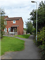
Lichen Gardens and Low Thatch, Hawkesley
There is a tiny stream off to the right
Image: © Chris Allen
Taken: 29 Aug 2015
0.25 miles