IMAGES TAKEN NEAR TO
Old Portway, BIRMINGHAM, B38 9RG
Introduction
This page details the photographs taken nearby to Old Portway, B38 9RG by members of the Geograph project.
The Geograph project started in 2005 with the aim of publishing, organising and preserving representative images for every square kilometre of Great Britain, Ireland and the Isle of Man.

There are currently over 7.5m images from over14,400 individuals and you can help contribute to the project by visiting https://www.geograph.org.uk
Image Map (Loading...)


Getting Data...Please wait
Leaflet Map data © OpenStreetMap
Images are licensed for reuse under creativecommons.org/licenses/by-sa/2.0
Notes
- Clicking on the map will re-center to the selected point.
- The higher the marker number, the further away the image location is from the centre of the postcode.
Image Listing (14 Images Found)
Images are licensed for reuse under creativecommons.org/licenses/by-sa/2.0
Image
Details
Distance

2

The Shannon public house
Located on Old Portway in Hawkesley, the pub's only recently changed its name from The Tunnel.
Image: © Richard Law
Taken: 26 Feb 2020
0.08 miles

4

Parade of shops in Hawkesley centre
These are mostly shops with flats above, by the look of things.
Image: © Richard Law
Taken: 26 Feb 2020
0.09 miles

6
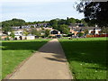
Public open space - Hawkesley
Traversed while walking from one portal to the other of the Wast Hill tunnel on the Worcester & Birmingham Canal. The tunnel is about 1.5 miles in length but the detour over the top was definitely longer.
Image: © Chris Allen
Taken: 29 Aug 2015
0.13 miles
7
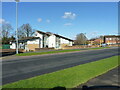
Hawkesley Community Centre
This is located on Edgewood Road in the centre of the housing estates.
Image: © Richard Law
Taken: 26 Feb 2020
0.16 miles
8

Houses in Hawkesley
These houses at Hawkesley around roughly directly above the Wast Hill Tunnel on the Worcester and Birmingham Canal.
Image: © Philip Halling
Taken: 20 Apr 2013
0.16 miles
9
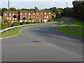
Longdales Road, Hawkesley - Wast Hill tunnel goes through under here
The Worcester & Birmingham Canal goes through under the road in the middle of this view.
Image: © Chris Allen
Taken: 29 Aug 2015
0.17 miles
10
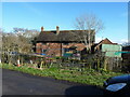
Goodrest Farmhouse
You'd hardly know it from the outside, but the relatively unassuming late 18th century brick exterior hides a (probable) 16th century timber-framed farmhouse, which was Grade II listed https://britishlistedbuildings.co.uk/101296563-goodrest-farmhouse-wythall#.YIc2f5BKjIU & https://historicengland.org.uk/listing/the-list/list-entry/1296563 in 1986.
Image: © Richard Law
Taken: 26 Feb 2020
0.18 miles