IMAGES TAKEN NEAR TO
Beech Walk, BIRMINGHAM, B38 9QF
Introduction
This page details the photographs taken nearby to Beech Walk, B38 9QF by members of the Geograph project.
The Geograph project started in 2005 with the aim of publishing, organising and preserving representative images for every square kilometre of Great Britain, Ireland and the Isle of Man.

There are currently over 7.5m images from over14,400 individuals and you can help contribute to the project by visiting https://www.geograph.org.uk
Image Map
Images are licensed for reuse under creativecommons.org/licenses/by-sa/2.0
Notes
- Clicking on the map will re-center to the selected point.
- The higher the marker number, the further away the image location is from the centre of the postcode.
Image Listing (29 Images Found)
Images are licensed for reuse under creativecommons.org/licenses/by-sa/2.0
Image
Details
Distance
1
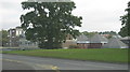
King's Norton High School
Situated on Shannon Road, this high school is quite extensive, and has a leisure centre connected to it.
Photo taken from corner of Teviot Grove
Image: © Michael Westley
Taken: 12 Oct 2010
0.06 miles
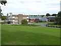
3
Across rooftops towards City
Looking across rooftops of Gillmore Drive, from Longdales Road, Hawkesley.
On the skyline, on left, is a church in King's Norton area, and just visible in the distance, the clock tower at Birmingham University.
Further to right are the high rise buildings of the city centre.
Image: © Michael Westley
Taken: 12 Oct 2010
0.07 miles
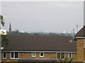
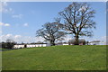
4
Hawkesley, southern residential area of Birmingham
From viewpoint on Longdales Road, looking across Rosebay Avenue in direction of grounds of King's Norton School and Leisure Centre. Across the hillside are further blocks of flats running along Redditch Road (A441)
Image: © Michael Westley
Taken: 12 Oct 2010
0.09 miles
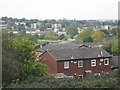
5
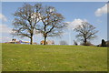
Trees and school at Hawkesley
Following the canal towpath on the Worcester and Birmingham Canal means a diversion here due to the canal passing through Wast Hill Tunnel.
Image: © Philip Halling
Taken: 20 Apr 2013
0.09 miles
6
Shannon Road, Hawkesley
The white building on the extreme left are Tunnel Cottages that are almost over the northern portal of the Wast Hill Tunnel on the Worcester & Birmingham Canal.
Image: © Chris Allen
Taken: 29 Aug 2015
0.10 miles
7
Housing at Hawkesley
Trees and housing at Hawkesley. Following the towpath of the Worcester and Birmingham Canal requires a diversion through here because of the Wast Hill Tunnel.
Image: © Philip Halling
Taken: 20 Apr 2013
0.11 miles
8
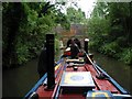
Wasthill Tunnel Northern portal
Narrow boat Rudd towing the butty Gifford emerging from the north end of the 2493 metre long Wast Hill Tunnel on the Worcester and Birmingham Canal. The foreground is probably in the adjacent square! The southern portal is in much more rural surroundings at Image and there are intermediate construction/ventilation shafts such as Image
Image: © David Stowell
Taken: 24 Jul 2003
0.12 miles
9
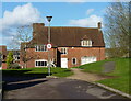
Primrose Hill farmhouse
This fine house is much restored in recent years from a rather derelict state. Although not visible from this direction, the left wall and the rear both have extensive timber framing exposed, and the main construction of the house is of mid-to-late 15th century date. It was Grade II* listed https://britishlistedbuildings.co.uk/101076230-primrose-hill-farmhouse-kings-norton-ward#.YIgrs7VKhPY & https://historicengland.org.uk/listing/the-list/list-entry/1076230 in 1973, at which time it was investigated by English Heritage, who found timbers dated to the 1440s and soon thereafter. There is also a large barn just offshot to the left here, of a similar vintage, and also recently converted to a dwelling.
Image: © Richard Law
Taken: 26 Feb 2020
0.12 miles
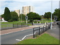
10
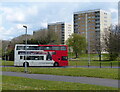
Tower blocks on the Primrose Hill Estate
Image: © Mat Fascione
Taken: 2 May 2021
0.14 miles