IMAGES TAKEN NEAR TO
Barratts Road, BIRMINGHAM, B38 9HU
Introduction
This page details the photographs taken nearby to Barratts Road, B38 9HU by members of the Geograph project.
The Geograph project started in 2005 with the aim of publishing, organising and preserving representative images for every square kilometre of Great Britain, Ireland and the Isle of Man.

There are currently over 7.5m images from over14,400 individuals and you can help contribute to the project by visiting https://www.geograph.org.uk
Image Map
Images are licensed for reuse under creativecommons.org/licenses/by-sa/2.0
Notes
- Clicking on the map will re-center to the selected point.
- The higher the marker number, the further away the image location is from the centre of the postcode.
Image Listing (11 Images Found)
Images are licensed for reuse under creativecommons.org/licenses/by-sa/2.0
Image
Details
Distance
1
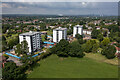
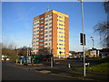
Loweswater House, Sandhurst House and Waltham House
Three recently refurbished residential blocks in Kings Norton.
Image: © TCExplorer
Taken: 22 Jun 2023
0.14 miles
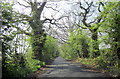
2
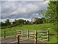
Sisefield Road turning circle, Pool Farm
The bus turning circle at the west end of Hillmeads Road where it meets Sisefield Road (foreground) was once the terminus of route 35 from Birmingham city centre, but has been largely unused since that route was extended to Hawkesley. It is loomed over by Speedwell House, the sole high rise block in this area; every post war council estate in Birmingham always seemed to have at least one tower block.
Image: © Richard Vince
Taken: 8 Dec 2012
0.16 miles
4
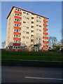
Waltham House flats
One of three identical blocks of flats on Icknield Street in Walker's Heath. The other two lie offshot to the left.
Image: © Richard Law
Taken: 29 Jan 2020
0.18 miles
5
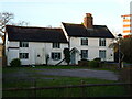
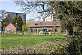
Walker's Heath Farmhouse
Walker's Heath Farmhouse consists of two distinct parts, the northern (right) side which is probably late 17th or early 18th century, whilst the lower part on the left is older, likely to be late 16th/early 17th century, and probably timber-framed beneath the more modern roughcast exterior. The whole place was Grade II listed https://britishlistedbuildings.co.uk/101075603-walkers-heath-farmhouse-kings-norton-ward#.X25WIWhKjIU & https://historicengland.org.uk/listing/the-list/list-entry/1075603 in 1976.
Image: © Richard Law
Taken: 29 Jan 2020
0.18 miles
6
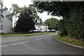
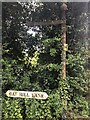
Icknield Street at the junction of Gay Hill Lane
This is the first line of buildings in the Birmingham area from this direction.
Image: © David Howard
Taken: 8 Aug 2021
0.19 miles
7
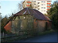
Cartshed at Walker's Heath Farm
Quite clearly a former agricultural building, which in all likelihood dates from the 18th century, and which was Grade II listed https://britishlistedbuildings.co.uk/101211079-cart-shed-at-walkers-heath-farm-kings-norton-ward#.X49WwtBKjIU & https://historicengland.org.uk/listing/the-list/list-entry/1211079 in 1976.
Image: © Richard Law
Taken: 29 Jan 2020
0.19 miles