IMAGES TAKEN NEAR TO
Lea End Lane, BIRMINGHAM, B38 9EB
Introduction
This page details the photographs taken nearby to Lea End Lane, B38 9EB by members of the Geograph project.
The Geograph project started in 2005 with the aim of publishing, organising and preserving representative images for every square kilometre of Great Britain, Ireland and the Isle of Man.

There are currently over 7.5m images from over14,400 individuals and you can help contribute to the project by visiting https://www.geograph.org.uk
Image Map
Images are licensed for reuse under creativecommons.org/licenses/by-sa/2.0
Notes
- Clicking on the map will re-center to the selected point.
- The higher the marker number, the further away the image location is from the centre of the postcode.
Image Listing (19 Images Found)
Images are licensed for reuse under creativecommons.org/licenses/by-sa/2.0
Image
Details
Distance
1
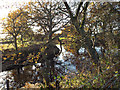
Pond near Big Forhill Farm
The North Worcestershire Path is taken on a detour to the north of the farm.
Image: © Robin Stott
Taken: 30 Nov 2013
0.03 miles
3
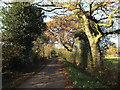
Lane to Big Forhill Farm, Forhill
The North Worcestershire Path comes this far then takes a detour to the north (right) of the farm.
Image: © Robin Stott
Taken: 30 Nov 2013
0.08 miles
4
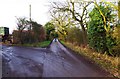
Private road to a farm, near Forhill, Worcs
This continuation of a public road is a private road giving access to a farm.
Image: © P L Chadwick
Taken: 17 Dec 2016
0.08 miles
5
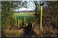
Stile on North Worcestershire Path, near Forhill, Worcs
This stile is on the North Worcestershire Path and takes the path from a lane into a field. Another public footpath is also accessed by this stile.
Image
Image: © P L Chadwick
Taken: 17 Dec 2016
0.09 miles
6
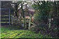
Stile on North Worcestershire Path, near Forhill, Worcs
This stile is on the North Worcestershire Path and takes the path from a field into a lane.
Image
Image: © P L Chadwick
Taken: 17 Dec 2016
0.09 miles
7
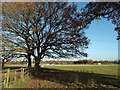
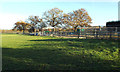
Paddocks, Forhill
Equestrian establishments seem to take up most of the land in this area – out of shot right, and on the Redhill Road in the distance. The North Worcestershire Path comes this way.
Image: © Robin Stott
Taken: 30 Nov 2013
0.10 miles
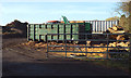
8
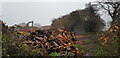
Log Processing, Forhill
This large site appears to be processing small pieces of timber, perhaps producing logs or firewood.
Image: © Paul Collins
Taken: 29 Nov 2020
0.10 miles
9
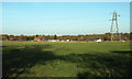
Paddocks and power lines, Forhill
Low-level power lines run along the Forhill-Redhill plateau. Properties in the distance, by Redhill Road, have extensive equestrian facilities. Just seen above the trees, left, are the tops of buildings in central Birmingham. http://www.geograph.org.uk/photo/4003351
Image: © Robin Stott
Taken: 30 Nov 2013
0.11 miles
10
Construction in a paddock near Little Forhill Farm, Forhill
Whether this will be for horses or poultry wasn't clear.
Image: © Robin Stott
Taken: 30 Nov 2013
0.11 miles