IMAGES TAKEN NEAR TO
Crabmill Lane, BIRMINGHAM, B38 0BP
Introduction
This page details the photographs taken nearby to Crabmill Lane, B38 0BP by members of the Geograph project.
The Geograph project started in 2005 with the aim of publishing, organising and preserving representative images for every square kilometre of Great Britain, Ireland and the Isle of Man.

There are currently over 7.5m images from over14,400 individuals and you can help contribute to the project by visiting https://www.geograph.org.uk
Image Map
Images are licensed for reuse under creativecommons.org/licenses/by-sa/2.0
Notes
- Clicking on the map will re-center to the selected point.
- The higher the marker number, the further away the image location is from the centre of the postcode.
Image Listing (13 Images Found)
Images are licensed for reuse under creativecommons.org/licenses/by-sa/2.0
Image
Details
Distance
1
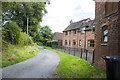
Crabmill Farm
Converted farm buildings at Crabmill Farm
Image: © P Gaskell
Taken: Unknown
0.01 miles
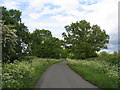
2
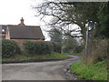
Public Bridleway to Walkers Heath
Driveway off Crabmill Lane near Crabmill Farm, that heads north-west towards Walkers Heath recreational ground and Gay Hill Lane
Image: © Michael Westley
Taken: 3 Mar 2011
0.02 miles
3
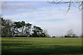
Pasture north of Crabmill Farm, and a glimpse of Birmingham
The pines could well have been planted to frame the view. The tall slim white building is the BT Tower in SP0687.
Image: © Robin Stott
Taken: 16 Mar 2014
0.04 miles
4
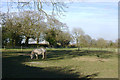
Paddocks by Crabmill Lane, Headley Heath
A common sight: horses as hobby. A pony nibbles grass down to bowling green length; fencing tape flutters in the breeze. Between the ivy-clad hedgerow oaks can be seen tower blocks of flats at Druid's Heath in Image
Image: © Robin Stott
Taken: 16 Mar 2014
0.06 miles
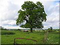
5
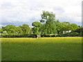
Crabtree Farm
Looking across the signs of spring in the fields from Crabmill Lane.
Image: © David Stowell
Taken: 27 May 2006
0.09 miles
7
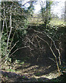
Disused pit by the bridleway below Crabmill Farm
The map marks a number such pits in the King's Wood and Headley Heath areas; perhaps they were for brick clay. Abundant ivy, hazel and holly here.
Image: © Robin Stott
Taken: 16 Mar 2014
0.16 miles
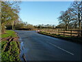
8
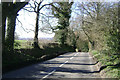
Descending Gay Hill northwest of Headley Heath
The road drops down 30 metres in 5-600 metres then climbs to Walker's Heath Image Southwest Birmingham is on the skyline.
Image: © Robin Stott
Taken: 16 Mar 2014
0.18 miles
10
Junction of Dark Lane with Middle Lane, Headley Heath
Image: © Richard Law
Taken: 29 Jan 2020
0.20 miles