1
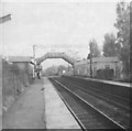
Holly Lane, Marston Green
Looking towards the village and train station.
Image: © Carl Baker
Taken: 10 Mar 2006
0.03 miles
2
Gateway into Sheldon Country Park
The park around the northern area of the airport is popular with plane spotters and families; this is one of the paths leading into the country park.
Image: © Richard Law
Taken: 17 Aug 2023
0.04 miles
3
Marston Green Railway Station
View from railway bridge looking down Holly Lane.
Image: © Carl Baker
Taken: 18 Aug 2006
0.04 miles
4
OS benchmark - Marston Green, no 10 Holly Lane
An OS cutmark in the brickwork at the front of no 10 Holly Lane. Originally levelled at 98.2m above Ordnance Datum Newlyn.
Image: © Richard Law
Taken: 16 Jan 2014
0.04 miles
5
Marston Green railway station
Opened in 1844 by the London & Birmingham Railway on the section of line from Coventry to Birmingham.
View south east towards Birmingham International and Coventry, although the start of the airport runway is immediately to the right of this image.
Image: © Nigel Thompson
Taken: 19 Nov 2011
0.05 miles
6
Outside Marston Green Station
Although actually within the borough of Solihull, Marston Green is an outer Birmingham suburb close to the airport. It has a busy station (behind the photographer in this view) that acts as a railhead for Chelmsley Wood.
Image: © Stephen McKay
Taken: 21 Feb 2019
0.05 miles
7
Marston Green station looking towards Birmingham
Image: © Roy Hughes
Taken: 6 Nov 2021
0.05 miles
8
Marston Green station
Image: © Roy Hughes
Taken: 6 Nov 2021
0.05 miles
9
Marston Green Railway Station.
Just beyond the bushes under the footbridge is the runway of Birmingham Airport. From the train the aeroplanes can be seen landing and taking off.
Image: © Angella Streluk
Taken: 19 Nov 2005
0.06 miles
10
Marston Green Station
Very few level crossings survived into the 70s on electrified railway lines. Here's one of them.
At the southern end of the platforms (closer to the current car parking) was once a level crossing and footbridge and original waiting rooms/ticket office.
Take a look at the old OS maps http://www.ponies.me.uk/maps/osmap.html to see the 1920s road that once crossed to Chapel House Farm and Canterbury Home, all now swallowed up by airport development.
Image: © Michael Westley
Taken: Unknown
0.07 miles


