IMAGES TAKEN NEAR TO
Reynoldstown Road, BIRMINGHAM, B36 8UR
Introduction
This page details the photographs taken nearby to Reynoldstown Road, B36 8UR by members of the Geograph project.
The Geograph project started in 2005 with the aim of publishing, organising and preserving representative images for every square kilometre of Great Britain, Ireland and the Isle of Man.

There are currently over 7.5m images from over14,400 individuals and you can help contribute to the project by visiting https://www.geograph.org.uk
Image Map
Images are licensed for reuse under creativecommons.org/licenses/by-sa/2.0
Notes
- Clicking on the map will re-center to the selected point.
- The higher the marker number, the further away the image location is from the centre of the postcode.
Image Listing (11 Images Found)
Images are licensed for reuse under creativecommons.org/licenses/by-sa/2.0
Image
Details
Distance
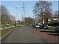
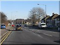
1
Housing on Bromford Drive at its junction with Bromford Road
Image: © Peter Whatley
Taken: 11 Feb 2012
0.14 miles
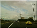
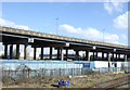
4
A Bromford Drive vista.
The scene is dominated by the M6 motorway and a high-voltage transmission line alongside it.
Image: © Peter Whatley
Taken: 11 Feb 2012
0.21 miles
5
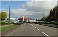
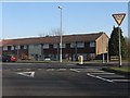
Fort Parkway to Castle Bromwich
There is a left turn at the roundabout into the Fort Retail Park.
Image: © Steve Daniels
Taken: 8 Apr 2014
0.23 miles
10
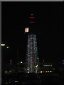
The Fort Tower (by night)
With Christmas lights from car park
Image: © Michael Westley
Taken: 10 Dec 2009
0.24 miles