IMAGES TAKEN NEAR TO
Bromford Drive, BIRMINGHAM, B36 8SL
Introduction
This page details the photographs taken nearby to Bromford Drive, B36 8SL by members of the Geograph project.
The Geograph project started in 2005 with the aim of publishing, organising and preserving representative images for every square kilometre of Great Britain, Ireland and the Isle of Man.

There are currently over 7.5m images from over14,400 individuals and you can help contribute to the project by visiting https://www.geograph.org.uk
Image Map
Images are licensed for reuse under creativecommons.org/licenses/by-sa/2.0
Notes
- Clicking on the map will re-center to the selected point.
- The higher the marker number, the further away the image location is from the centre of the postcode.
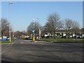
Image Listing (19 Images Found)
Images are licensed for reuse under creativecommons.org/licenses/by-sa/2.0
Image
Details
Distance


5

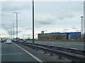
Bromford Drive
Dead-end of road on housing estate, near to elevated section of M6 motorway. Fort Dunlop can just be seen beyond the motorway.
Image: © Michael Westley
Taken: 21 Jan 2012
0.11 miles
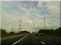
6

Close by the M6
The elevated road is the M6 and the River Tame runs between the railway track and the motorway.
Image: © Malcolm Neal
Taken: 8 Jul 2019
0.12 miles

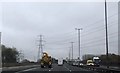
9
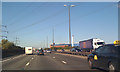
Power lines cross M6, Bromford
M6 North heads past junction 5 towards Fort Dunlop. Formerly the Dunlop tyre factory, now a Travelodge hotel, it is a landmark on this stretch of the M6. The apparently wonky lighting column is an artefact of photography at speed with a no-frills camera-phone. This location viewed from the southbound carriageway is Image
Image: © Robin Stott
Taken: 25 Sep 2010
0.17 miles