IMAGES TAKEN NEAR TO
Kempson Road, BIRMINGHAM, B36 8LR
Introduction
This page details the photographs taken nearby to Kempson Road, B36 8LR by members of the Geograph project.
The Geograph project started in 2005 with the aim of publishing, organising and preserving representative images for every square kilometre of Great Britain, Ireland and the Isle of Man.

There are currently over 7.5m images from over14,400 individuals and you can help contribute to the project by visiting https://www.geograph.org.uk
Image Map
Images are licensed for reuse under creativecommons.org/licenses/by-sa/2.0
Notes
- Clicking on the map will re-center to the selected point.
- The higher the marker number, the further away the image location is from the centre of the postcode.
Image Listing (31 Images Found)
Images are licensed for reuse under creativecommons.org/licenses/by-sa/2.0
Image
Details
Distance
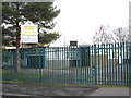
1

Doctors Surgery
On Kempson Road, corner of Dreghorn Road
Image: © Michael Westley
Taken: 21 Jan 2012
0.03 miles
2

Edstone Mews
Central Birmingham housing, close to the M6
Image: © Richard Law
Taken: 14 May 2014
0.07 miles
3

St Wilfrid's Catholic Church
Part of the Archdiocese of Birmingham, a modern Catholic Church on Shawsdale Road.
Image: © Richard Law
Taken: 14 May 2014
0.11 miles
4
The Pines School
Special School on Dreghorn Road, Hodge Hill
http://www.thepinesspecialschool.com/
Image: © Michael Westley
Taken: 21 Jan 2012
0.11 miles
5
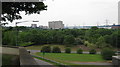
M6 Junction 5 and the City
Eastern outskirts of Birmingham City ends near Castle Bromwich.
Photo taken from bottom of Castle Bromwich churchyard, looking west in direction of Bromford housing estates.
Fort Dunlop can just be seen on the right
Image: © Michael Westley
Taken: 5 Jun 2010
0.14 miles
6

Modern housing, Hodge Hill
Modern flats / houses on Shawdale Road - St Winifred's RC church to the right
Image: © Michael Westley
Taken: 21 Jan 2012
0.15 miles
7

Firs Primary School
On Dreghorn Road, next to Image]
Image: © Michael Westley
Taken: 21 Jan 2012
0.16 miles
8

Firs estate-site of demolished tower blocks
Just visible to the right of the photo is the elevated M6 motorway at Castle Bromwich, this is the extreme northern extent of the Firs estate. The overgrown roadway is all that is left of the site of what used to be a cluster of five 8-storey tower blocks, each with 32 flats; they were named Oregon, Lebanon, Douglas, Spruce & Sylvester house. Built in 1958, in a seemingly ill-advised area, rather too near to the flood-prone River Tame, which runs more or less parallel with the M6, the area is quite low-lying and very damp. The damp/flooding problem wasn't addressed when the site was built and this caused such severe rising damp in the tower blocks that Birmingham City council were unable to rent the ground floor flats for many years; there was also a problem with subsidence so the decision was taken to demolish all five tower blocks and some ordinary houses that occupied the same low-lying land in 2002, this waste land is so overgrown now that it gives little clue to its former usage, apart from the apparently random and winding tarmacadam that used to surround the tower blocks.
Image: © phillip andrew carl taylor
Taken: 27 Nov 2012
0.17 miles
9

Wild marshy Castle Bromwich
Below the gardens of Castle Bromwich Hall is an area of land left to the wilds of nature. Here there is still a stream and areas of water (on OS Map too) that is covered with bulrushes.
Image: © Michael Westley
Taken: 21 Jan 2012
0.17 miles
