IMAGES TAKEN NEAR TO
Collingbourne Avenue, BIRMINGHAM, B36 8JP
Introduction
This page details the photographs taken nearby to Collingbourne Avenue, B36 8JP by members of the Geograph project.
The Geograph project started in 2005 with the aim of publishing, organising and preserving representative images for every square kilometre of Great Britain, Ireland and the Isle of Man.

There are currently over 7.5m images from over14,400 individuals and you can help contribute to the project by visiting https://www.geograph.org.uk
Image Map
Images are licensed for reuse under creativecommons.org/licenses/by-sa/2.0
Notes
- Clicking on the map will re-center to the selected point.
- The higher the marker number, the further away the image location is from the centre of the postcode.
Image Listing (8 Images Found)
Images are licensed for reuse under creativecommons.org/licenses/by-sa/2.0
Image
Details
Distance
1
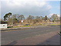
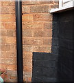
Site of The Comet
The Comet pub once stood here; the benchmark on its east face has gone too.
Image: © Richard Law
Taken: 22 Jan 2015
0.01 miles
2
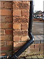
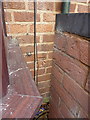
OS benchmark - Hodgehill, 23 Standlake Avenue
An OS cutmark on the west-facing wall of no 23 Standlake Ave; originally levelled at 112.04m above Ordnance Datum Newlyn.
Image: © Richard Law
Taken: 22 Jan 2015
0.11 miles
3
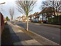
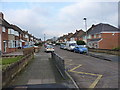
Collingbourne Avenue, Hodgehill
A residential street between Bromford Road and Chipperfield Road. Mostly 1950s semis, there's also a small parade of shops a little further on, although The Comet pub just beyond the far end of this picture has been demolished.
Image: © Richard Law
Taken: 22 Jan 2015
0.13 miles
4
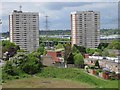
Bromford Drive housing
View from hillside north of Collingbourne Avenue of housing on Bromford Drive. Between the blocks of flats can be seen Image]
Image: © Michael Westley
Taken: 15 May 2010
0.13 miles
5
OS benchmark - Hodgehill, 93 Twycross Grove
An OS cutmark on the brickwork of one of the houses at the end of Twycross Grove; originally levelled at 111.8m above Ordnance Datum Newlyn.
Image: © Richard Law
Taken: 22 Jan 2015
0.19 miles
6
OS benchmark - Hodgehill, 315 Bromford Road
An OS cutmark on the front wall of 315 Bromford Road; originally levelled at 109.97m above Ordnance Datum Newlyn.
Image: © Richard Law
Taken: 22 Jan 2015
0.19 miles
7
Twycross Grove
Semis in a cul-de-sac on the northwest side of Hodgehill
Image: © Richard Law
Taken: 22 Jan 2015
0.20 miles
8
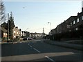
Final approach over Chipperfield Road
A Boeing 737 is prepared for landing at Birmingham airport, viewed from amongst the houses of Bromford.
Image: © Peter Whatley
Taken: 11 Feb 2012
0.25 miles