IMAGES TAKEN NEAR TO
Bromford Road, BIRMINGHAM, B36 8ET
Introduction
This page details the photographs taken nearby to Bromford Road, B36 8ET by members of the Geograph project.
The Geograph project started in 2005 with the aim of publishing, organising and preserving representative images for every square kilometre of Great Britain, Ireland and the Isle of Man.

There are currently over 7.5m images from over14,400 individuals and you can help contribute to the project by visiting https://www.geograph.org.uk
Image Map
Images are licensed for reuse under creativecommons.org/licenses/by-sa/2.0
Notes
- Clicking on the map will re-center to the selected point.
- The higher the marker number, the further away the image location is from the centre of the postcode.
Image Listing (14 Images Found)
Images are licensed for reuse under creativecommons.org/licenses/by-sa/2.0
Image
Details
Distance
1
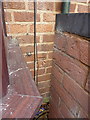
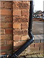
OS benchmark - Hodgehill, 315 Bromford Road
An OS cutmark on the front wall of 315 Bromford Road; originally levelled at 109.97m above Ordnance Datum Newlyn.
Image: © Richard Law
Taken: 22 Jan 2015
0.05 miles
2
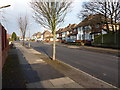
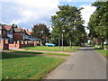
Collingbourne Avenue, Hodgehill
A residential street between Bromford Road and Chipperfield Road. Mostly 1950s semis, there's also a small parade of shops a little further on, although The Comet pub just beyond the far end of this picture has been demolished.
Image: © Richard Law
Taken: 22 Jan 2015
0.06 miles
4
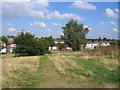
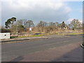
Hodge Hill Common
This area of common land still provides a welcome green area in the midst of this area of urban development.
Image: © David Stowell
Taken: 23 Sep 2006
0.14 miles
5
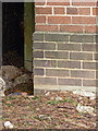
OS benchmark - Hodgehill, 23 Standlake Avenue
An OS cutmark on the west-facing wall of no 23 Standlake Ave; originally levelled at 112.04m above Ordnance Datum Newlyn.
Image: © Richard Law
Taken: 22 Jan 2015
0.15 miles
6
Site of The Comet
The Comet pub once stood here; the benchmark on its east face has gone too.
Image: © Richard Law
Taken: 22 Jan 2015
0.20 miles
7
Hodge Hill Common
Houses beside Hodge Hill Common. A pleasant green area in the middle of suburbia.
Image: © David Stowell
Taken: 23 Sep 2006
0.20 miles
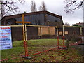
8
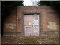
OS benchmark - Hodgehill, Twycross Grove substation
An OS cutmark on the south face of the electrical substation; originally levelled at 113.73m above Ordnance Datum Newlyn.
Image: © Richard Law
Taken: 22 Jan 2015
0.20 miles
9
Twycross Grove electrical substation
Apparently, no matter how high or spiky the fence around these places, the spray-can generation will find a way to get in there and make their mark. How classy.
Image: © Richard Law
Taken: 22 Jan 2015
0.20 miles
10
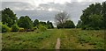
Hodge Hill Common
This small green oasis was common land before surrounding fields were developed in the 20th century, and so escaped being built over.
Image: © Paul Collins
Taken: 11 May 2020
0.22 miles