IMAGES TAKEN NEAR TO
Freasley Road, BIRMINGHAM, B34 7PS
Introduction
This page details the photographs taken nearby to Freasley Road, B34 7PS by members of the Geograph project.
The Geograph project started in 2005 with the aim of publishing, organising and preserving representative images for every square kilometre of Great Britain, Ireland and the Isle of Man.

There are currently over 7.5m images from over14,400 individuals and you can help contribute to the project by visiting https://www.geograph.org.uk
Image Map
Images are licensed for reuse under creativecommons.org/licenses/by-sa/2.0
Notes
- Clicking on the map will re-center to the selected point.
- The higher the marker number, the further away the image location is from the centre of the postcode.
Image Listing (12 Images Found)
Images are licensed for reuse under creativecommons.org/licenses/by-sa/2.0
Image
Details
Distance
1
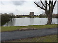
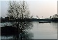
The Shard End lake
A fishing pool on the north side of the Norman Chamberlain playing fields. And, on the day of my visit, a place for one of the local yoofs to rag a two-stroke dirt bike up and down on the grass.; he was not improving the turf one jot.
Image: © Richard Law
Taken: 20 Feb 2015
0.08 miles
2
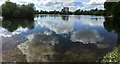
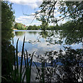
Reflections in the Lake
Shard End Lake from beside Pithall Road
Image: © Michael Westley
Taken: 7 May 2022
0.09 miles
3
T S Stirling at the east end of the lake, Shard End, east Birmingham
T S Stirling is a Sea Cadets Training Ship: https://www.sea-cadets.org/birminghamstirling Land side is on Pithall Road.
Image: © Robin Stott
Taken: 21 Jun 2018
0.09 miles
4
Shard End Lake, Solihull (1980)
A man-made lake created out of an old quarry.
Image: © Graham Hogg
Taken: Unknown
0.10 miles
5
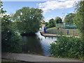
Shard End Lake, Shard End, east Birmingham
The mast to the right of the flats belongs to the Sea Cadets at the T.S. Stirling off Pithall Road. The site adjoins the Norman Chamberlain Recreation Ground, itself part of the extensive Kingfisher Country Park along the River Cole. On a map of 1938 Shard End is a typical Arden hamlet around a couple of farms. By 1951 the Shard End estate has been built; the lake is labelled 'Old Gravel Pit', perhaps dug in the war years.
Image: © Robin Stott
Taken: 21 Jun 2018
0.10 miles
6

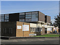
Police Station in Shard End
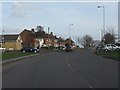
This lies at the corner of Packington Avenue and Pithall Road, but is no longer open to the public.
Image: © Richard Law
Taken: 20 Feb 2015
0.12 miles
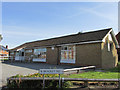
7
Pulse Point Fitness Centre, corner of The Shardway and Packington Avenue, Shard End, Birmingham
Image: © Ann Causer
Taken: 23 Aug 2014
0.18 miles
9
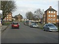
Aylesford Hall, corner of Bradley Road and Packington Avenue, Shard End, Birmingham
Image: © Ann Causer
Taken: 23 Aug 2014
0.22 miles