IMAGES TAKEN NEAR TO
Brownfield Road, BIRMINGHAM, B34 7DY
Introduction
This page details the photographs taken nearby to Brownfield Road, B34 7DY by members of the Geograph project.
The Geograph project started in 2005 with the aim of publishing, organising and preserving representative images for every square kilometre of Great Britain, Ireland and the Isle of Man.

There are currently over 7.5m images from over14,400 individuals and you can help contribute to the project by visiting https://www.geograph.org.uk
Image Map
Images are licensed for reuse under creativecommons.org/licenses/by-sa/2.0
Notes
- Clicking on the map will re-center to the selected point.
- The higher the marker number, the further away the image location is from the centre of the postcode.
Image Listing (10 Images Found)
Images are licensed for reuse under creativecommons.org/licenses/by-sa/2.0
Image
Details
Distance
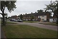
1
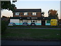
The Trident Public House
This pub is on Timberley Road.
Image: © Carl Baker
Taken: 7 Sep 2006
0.06 miles
8
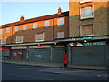
Local shops
These shops in Shard End Crescent are still open, but the flats above are all boarded up and not occupied.
Image: © Carl Baker
Taken: 7 Sep 2006
0.21 miles
10
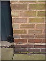
OS benchmark - Shard End, flat 439 Heath Way
An OS cutmark on the brickwork of a block of flats at the corner of Heath Way and Shard End Crescent. Originally levelled at 98.51m above Ordnance Datum Newlyn.
Image: © Richard Law
Taken: 20 Feb 2015
0.23 miles