IMAGES TAKEN NEAR TO
Cherry Lea, BIRMINGHAM, B34 6TJ
Introduction
This page details the photographs taken nearby to Cherry Lea, B34 6TJ by members of the Geograph project.
The Geograph project started in 2005 with the aim of publishing, organising and preserving representative images for every square kilometre of Great Britain, Ireland and the Isle of Man.

There are currently over 7.5m images from over14,400 individuals and you can help contribute to the project by visiting https://www.geograph.org.uk
Image Map
Images are licensed for reuse under creativecommons.org/licenses/by-sa/2.0
Notes
- Clicking on the map will re-center to the selected point.
- The higher the marker number, the further away the image location is from the centre of the postcode.
Image Listing (14 Images Found)
Images are licensed for reuse under creativecommons.org/licenses/by-sa/2.0
Image
Details
Distance
1

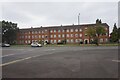
Copplestone Close, Colehall
Near Shard End, and next to Banks' pub
Image: © Michael Westley
Taken: 21 May 2010
0.03 miles
2

Riverside walk, River Cole
Riverside view, approaching Old Forest Way, near Colehall.
Image: © Michael Westley
Taken: 21 May 2010
0.05 miles
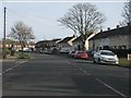
5
SW along Brook Meadow Road
Looking along the road, mainly past 1960s or 1970s housing, in the general direction of Buckland End.
Image: © Richard Law
Taken: 6 Jan 2015
0.14 miles
7
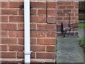
OS benchmark - Buckland End, 456 Heathway
An OS cutmark on the front wall of no 456 Heathway; originally levelled at 101.57m above Ordnance Datum Newlyn.
Image: © Richard Law
Taken: 6 Jan 2015
0.15 miles
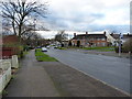
8
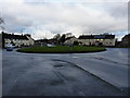
Brownmead roundabout
In the area of Buckland End, the roundabout marks the point where Heathway crosses the Brook Meadow Road/School Lane junction. The solar PV panels on the roof of the house (half right) can't have been very productive on this particular dull afternoon.
Image: © Richard Law
Taken: 6 Jan 2015
0.16 miles
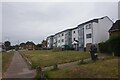
10
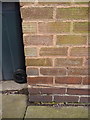
OS benchmark - Shard End, flat 439 Heath Way
An OS cutmark on the brickwork of a block of flats at the corner of Heath Way and Shard End Crescent. Originally levelled at 98.51m above Ordnance Datum Newlyn.
Image: © Richard Law
Taken: 20 Feb 2015
0.20 miles