IMAGES TAKEN NEAR TO
Shopton Road, BIRMINGHAM, B34 6NT
Introduction
This page details the photographs taken nearby to Shopton Road, B34 6NT by members of the Geograph project.
The Geograph project started in 2005 with the aim of publishing, organising and preserving representative images for every square kilometre of Great Britain, Ireland and the Isle of Man.

There are currently over 7.5m images from over14,400 individuals and you can help contribute to the project by visiting https://www.geograph.org.uk
Image Map
Images are licensed for reuse under creativecommons.org/licenses/by-sa/2.0
Notes
- Clicking on the map will re-center to the selected point.
- The higher the marker number, the further away the image location is from the centre of the postcode.
Image Listing (22 Images Found)
Images are licensed for reuse under creativecommons.org/licenses/by-sa/2.0
Image
Details
Distance
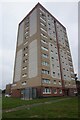
2
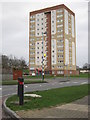
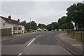
Brunswick House, Bucklands End
Block of flats on corner of Shopton Road and Heath Way
Image: © Michael Westley
Taken: 21 Jan 2012
0.06 miles
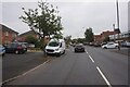
5
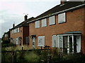
Empty houses
These houses are on Heathland Avenue and will be renovated or knocked down and replaced very soon.
Image: © Carl Baker
Taken: 7 Oct 2006
0.10 miles
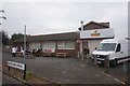
7
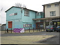
The Hart Centre
Adult Education Centre on Heath Road, Bucklands End, next to a small shopping area and car park
Image: © Michael Westley
Taken: 21 Jan 2012
0.11 miles
8
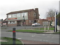
The Heathway PH
Public House on Heath Way, Bucklands End
Image: © Michael Westley
Taken: 21 Jan 2012
0.12 miles