IMAGES TAKEN NEAR TO
Ashville Avenue, BIRMINGHAM, B34 6LU
Introduction
This page details the photographs taken nearby to Ashville Avenue, B34 6LU by members of the Geograph project.
The Geograph project started in 2005 with the aim of publishing, organising and preserving representative images for every square kilometre of Great Britain, Ireland and the Isle of Man.

There are currently over 7.5m images from over14,400 individuals and you can help contribute to the project by visiting https://www.geograph.org.uk
Image Map
Images are licensed for reuse under creativecommons.org/licenses/by-sa/2.0
Notes
- Clicking on the map will re-center to the selected point.
- The higher the marker number, the further away the image location is from the centre of the postcode.
Image Listing (26 Images Found)
Images are licensed for reuse under creativecommons.org/licenses/by-sa/2.0
Image
Details
Distance
1
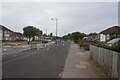
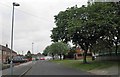
Road junction in Buckland End
Heathland Avenue leaves the B4114 Bradford Road.
Image: © Richard Law
Taken: 14 May 2014
0.07 miles
2
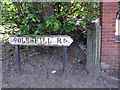
Old Boundary Marker
Marked Boundary between Castle Bromwich/Warwickshire and the City of Birmingham.
On Coleshill Road, B4114 (was A47) Area was incorporated into West Midlands County.
Image: © Mike Richardes
Taken: 1 Jun 2009
0.08 miles
5
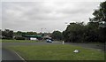
Heathlands Primary School
Off Heath Way, Bucklands End
http://www.ofsted.gov.uk/inspection-reports/find-inspection-report/provider/ELS/103382
Image: © Michael Westley
Taken: 21 Jan 2012
0.15 miles
6
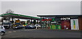
The Clock Garage, Hodge Hill
This large filling station was built around 2012, replacing a mid-twentieth century garage building that was topped by a large clock. Situated at a busy main junction, it is a well-known landmark and in a nod to the past, the present building also has a clock on front of the shop building and not visible in this shot. See https://billdargue.jimdofree.com/placenames-gazetteer-a-to-y/places-c/the-clock/
Image: © Paul Collins
Taken: 28 Jan 2022
0.15 miles
7
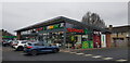
The Clock Garage, Hodge Hill
This large filling station was built around 2012, replacing a mid-twentieth century building that was topped by a large clock. Situated at a busy main junction, it is a well-known landmark and in a nod to the past, the present building also has a clock, just visible in this shot on the brick section to the left of the word 'Costa'. See https://billdargue.jimdofree.com/placenames-gazetteer-a-to-y/places-c/the-clock/
Image: © Paul Collins
Taken: 28 Jan 2022
0.15 miles
8
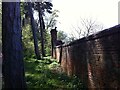
The Dream of the Sphinx, Castle Bromwich
There are sphinxes at the bottom of the garden. One can be seen here reposing on a pillar at a corner of the garden wall at Castle Bromwich Hall, in the suburbs of Birmingham & Solihull. The photo was taken from the wooded area outside the walled garden. The sphinx has a double facing her from the opposite corner, some distance away.
The formal gardens to the west of Castle Bromwich Hall were laid out by the Bridgeman family in stages, starting in 1701. Sir John Bridgeman II bought two limestone sphinx statues in 1745 for £30 and installed them with inscriptions. During the 20th century the Bridgeman family ceased living in the Hall; the gardens became overgrown and the walls and buildings decayed. They have been restored since 1985 by the Castle Bromwich Hall Gardens Trust. The Hall itself is now a hotel and, unlike the gardens, is not open to the public. The garden walls were listed by Historic England in 2020; see their description of the site here https://historicengland.org.uk/listing/the-list/list-entry/1472046 .
Image: © A J Paxton
Taken: 20 Apr 2019
0.17 miles