IMAGES TAKEN NEAR TO
Cole Hall Lane, BIRMINGHAM, B34 6HE
Introduction
This page details the photographs taken nearby to Cole Hall Lane, B34 6HE by members of the Geograph project.
The Geograph project started in 2005 with the aim of publishing, organising and preserving representative images for every square kilometre of Great Britain, Ireland and the Isle of Man.

There are currently over 7.5m images from over14,400 individuals and you can help contribute to the project by visiting https://www.geograph.org.uk
Image Map
Images are licensed for reuse under creativecommons.org/licenses/by-sa/2.0
Notes
- Clicking on the map will re-center to the selected point.
- The higher the marker number, the further away the image location is from the centre of the postcode.
Image Listing (12 Images Found)
Images are licensed for reuse under creativecommons.org/licenses/by-sa/2.0
Image
Details
Distance
1
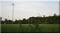
Rugby football pitches, Colehall
Pitches off Cole Hall Lane near River Cole
Image: © Michael Westley
Taken: 21 May 2010
0.07 miles
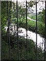
2
River Cole, Colehall
View from footbridge looking down on river and ahead to single lane road bridge (Cole Hall Lane)
Image: © Michael Westley
Taken: 21 May 2010
0.08 miles
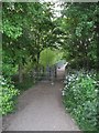
3
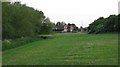
Park view alongside River Cole
Just off Cole Hall Lane alongside meandering River Cole
Image: © Michael Westley
Taken: 21 May 2010
0.11 miles
4
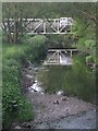
Footbridge over River Cole
Linking rugby pitches with housing on north side of river, Bucklands End and Colehall
Image: © Michael Westley
Taken: 21 May 2010
0.11 miles
5
River Cole, west from Colehall footbridge
View from footbridge linking grounds south of housing estate with rugby pitches and other estate, looking west
Image: © Michael Westley
Taken: 21 May 2010
0.15 miles
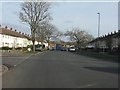
7

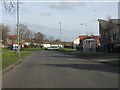
Copplestone Close, Colehall
Near Shard End, and next to Banks' pub
Image: © Michael Westley
Taken: 21 May 2010
0.21 miles
8
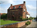
The Poacher's Pocket Pub
This pub sits back off Cole Hall Lane.
Image: © Carl Baker
Taken: 12 Sep 2006
0.21 miles
9

Riverside walk, River Cole
Riverside view, approaching Old Forest Way, near Colehall.
Image: © Michael Westley
Taken: 21 May 2010
0.21 miles