IMAGES TAKEN NEAR TO
Falmouth Road, BIRMINGHAM, B34 6EJ
Introduction
This page details the photographs taken nearby to Falmouth Road, B34 6EJ by members of the Geograph project.
The Geograph project started in 2005 with the aim of publishing, organising and preserving representative images for every square kilometre of Great Britain, Ireland and the Isle of Man.

There are currently over 7.5m images from over14,400 individuals and you can help contribute to the project by visiting https://www.geograph.org.uk
Image Map
Images are licensed for reuse under creativecommons.org/licenses/by-sa/2.0
Notes
- Clicking on the map will re-center to the selected point.
- The higher the marker number, the further away the image location is from the centre of the postcode.
Image Listing (9 Images Found)
Images are licensed for reuse under creativecommons.org/licenses/by-sa/2.0
Image
Details
Distance
1
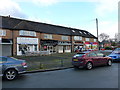
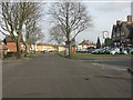
Shops on Maryland Avenue
A small parade of shops between Hodgehill and Colehall
Image: © Richard Law
Taken: 6 Jan 2015
0.08 miles
2
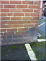
OS benchmark - The Raven pub
An OS cutmark in the front (NW) face of the pub; originally levelled at 96.54m above Ordnance Datum Newlyn.
Image: © Richard Law
Taken: 6 Jan 2015
0.13 miles
5
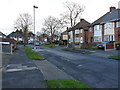
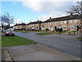
Fowey Road, Buckland End
1950s semis on a part of the housing estate between Buckland End and Hodge Hill Common.
Image: © Richard Law
Taken: 6 Jan 2015
0.15 miles
6
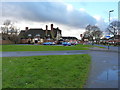
The Raven, Hodge Hill
A grill/restaurant pub on Hodge Hill Road.
Image: © Richard Law
Taken: 6 Jan 2015
0.15 miles
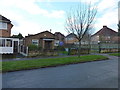
7
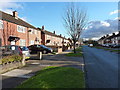
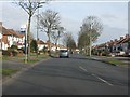
Bucklands End Lane
Houses on an estate between Bucklands End and Hodge Hill.
Image: © Richard Law
Taken: 6 Jan 2015
0.18 miles
8
Hodge Hill Gospel Church
A small church tucked away in the back streets of Buckland End.
Image: © Richard Law
Taken: 6 Jan 2015
0.19 miles