IMAGES TAKEN NEAR TO
Southbourne Avenue, BIRMINGHAM, B34 6AJ
Introduction
This page details the photographs taken nearby to Southbourne Avenue, B34 6AJ by members of the Geograph project.
The Geograph project started in 2005 with the aim of publishing, organising and preserving representative images for every square kilometre of Great Britain, Ireland and the Isle of Man.

There are currently over 7.5m images from over14,400 individuals and you can help contribute to the project by visiting https://www.geograph.org.uk
Image Map
Images are licensed for reuse under creativecommons.org/licenses/by-sa/2.0
Notes
- Clicking on the map will re-center to the selected point.
- The higher the marker number, the further away the image location is from the centre of the postcode.
Image Listing (13 Images Found)
Images are licensed for reuse under creativecommons.org/licenses/by-sa/2.0
Image
Details
Distance
1
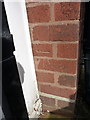
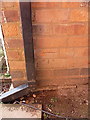
OS benchmark - Hodgehill, 10 Southbourne Avenue
An OS cutmark on the front wall of no 10 Southbourne Ave; originally levelled at 108.91m above Ordnance Datum Newlyn.
Image: © Richard Law
Taken: 25 Feb 2015
0.04 miles
4
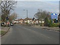
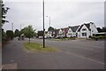
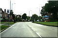
Southbourne Avenue, Hodgehill
A large development of probably 1960s semis and housing to the north of Stechford.
Image: © Richard Law
Taken: 25 Feb 2015
0.13 miles
5
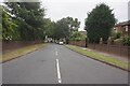
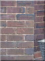
OS benchmark - Hodgehill, 159 Coleshill Road
An OS cutmark by the front door of 159 Coleshill Road; originally levelled at 111.66m above Ordnance Datum Newlyn, and very lucky not to have been covered up by recent cladding/rendering of the house.
Image: © Richard Law
Taken: 25 Feb 2015
0.18 miles
7
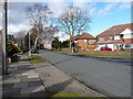
OS benchmark - Hodgehill, 50 Coleshill Road
An OS cutmark on the side wall of the house on Coleshill Road; originally levelled at 112.84m above Ordnance Datum Newlyn.
Image: © Richard Law
Taken: 25 Feb 2015
0.21 miles
10
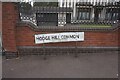
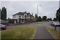
Hodge Hill Common off Coleshill Road, Birmingham
Image: © Ian S
Taken: 23 Jul 2021
0.23 miles